Cotija de la Paz night lights from space
Night Light of Cotija de la Paz (Michoacán) from space (Mexico) Src. Average luminocity for 10x10km area is 3.1963% and for 50x50km: 2.4555%.
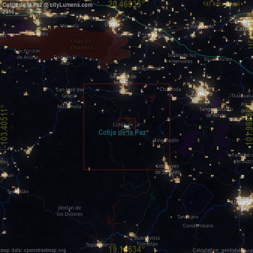
Analysis of Cotija de la Paz night lights 2016
Square area 10x10 km:
 0%
0%90-99
0%80-89
0.83%70-79
0.83%60-69
0.83%50-59
0%40-49
1.65%30-39
0.83%20-29
0%10-19
0%0-9
95.04%Square area 50x50 km:
0.02%90-99
0.05%80-89
0.41%70-79
0.51%60-69
0.55%50-59
0.35%40-49
0.5%30-39
0.45%20-29
0.5%10-19
1.51%0-9
95.13%Clear (daylight) street map image can be seen on geolist.org.
Map coordinates:
20° 28' 9.7" North, 103° 24' 18.4" West
19° 48' 33.2" North, 102° 42' 7.1" West
19° 8' 46.8" North, 101° 59' 55.9" West
Some cities around Cotija de la Paz sort by population:
• Sahuayo de Morelos
27.8 km =17.3 mi,  357°
357°
• Los Reyes de Salgado
34.2 km =21.3 mi,  135°
135°
• Jiquílpan de Juárez
20.7 km =12.9 mi,  354°
354°
• Santiago Tangamandapio
32.3 km =20.1 mi,  59°
59°
• Tarécuato
25.1 km =15.6 mi,  81°
81°
• Tingüindín
24.4 km =15.2 mi,  108°
108°
• Santa Clara de Valladares
29.2 km =18.1 mi,  131°
131°
• Chavinda
33.5 km =20.8 mi,  49°
49°
4012685 (p: 13,560)
Sources (retrieved 2019-11-25):
» Earth at Night: Flat Maps 2012, 2016