San Pedro Zictepec night lights from space
Night Light of San Pedro Zictepec (Morelos) from space (Mexico) Src. Average luminocity for 10x10km area is 36.0974% and for 50x50km: 29.6549%.
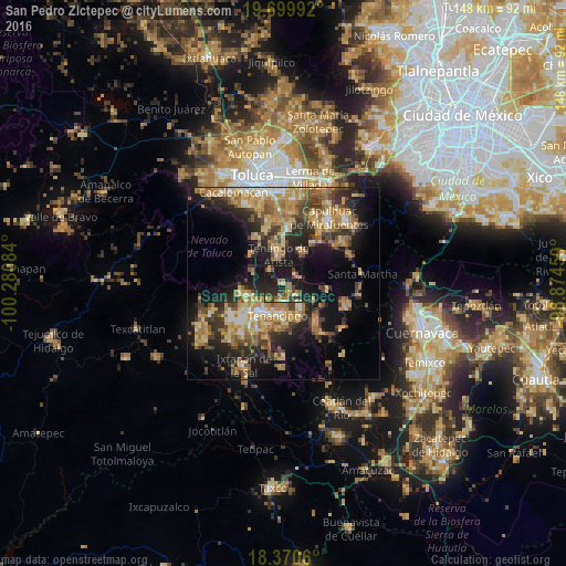
Analysis of San Pedro Zictepec night lights 2016
Square area 10x10 km:
 0.43%
0.43%90-99
1.08%80-89
8.23%70-79
4.33%60-69
8.44%50-59
5.63%40-49
7.36%30-39
7.58%20-29
17.75%10-19
38.31%0-9
0.87%Square area 50x50 km:
1.49%90-99
2.48%80-89
6.34%70-79
5.93%60-69
6.69%50-59
3.82%40-49
5.46%30-39
5%20-29
8.55%10-19
15.84%0-9
38.41%Clear (daylight) street map image can be seen on geolist.org.
Map coordinates:
19° 41' 59.7" North, 100° 16' 51" West
19° 2' 11.7" North, 99° 34' 39.8" West
18° 22' 14.2" North, 98° 52' 28.5" West
Some cities around San Pedro Zictepec sort by population:
• Tenango de Arista
7.7 km =4.8 mi,  350°
350°
• Tenancingo de Degollado
8.5 km =5.3 mi,  188°
188°
• Villa Guerrero
10.6 km =6.6 mi,  218°
218°
• Santa María Rayón
12.4 km =7.7 mi,  359°
359°
• Malinalco
13 km =8.1 mi,  138°
138°
• Santa María Jajalpa
9.4 km =5.8 mi,  27°
27°
• Santa Ana Ixtlahuatzingo (Santa Ana)
8.8 km =5.5 mi,  213°
213°
• San Bartolomé Atlatlahuca
5 km =3.1 mi,  317°
317°
3827299 (p: 5,571)
Sources (retrieved 2019-11-25):
» Earth at Night: Flat Maps 2012, 2016