Isla del Bosque night lights from space
Night Light of Isla del Bosque (Sinaloa) from space (Mexico) Src. Average luminocity for 10x10km area is 2.7103% and for 50x50km: 1.2118%.
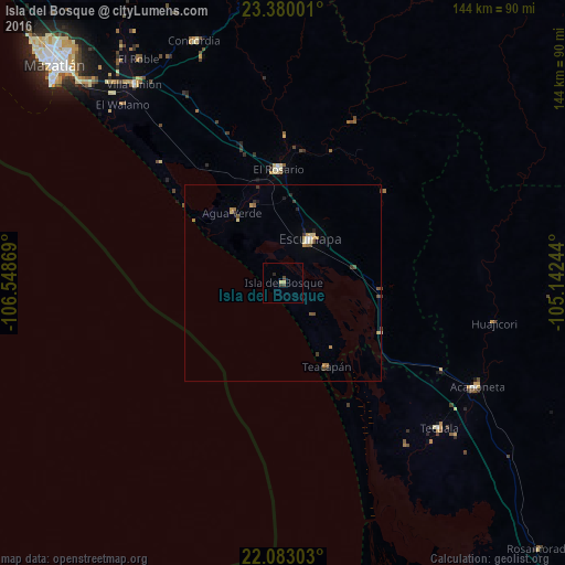
Analysis of Isla del Bosque night lights 2016
Square area 10x10 km:
 0%
0%90-99
0%80-89
1.39%70-79
0.2%60-69
0%50-59
0%40-49
1.59%30-39
0.79%20-29
0.79%10-19
0%0-9
95.24%Square area 50x50 km:
0.06%90-99
0.04%80-89
0.29%70-79
0.17%60-69
0.25%50-59
0.13%40-49
0.3%30-39
0.25%20-29
0.2%10-19
0.1%0-9
98.22%Clear (daylight) street map image can be seen on geolist.org.
Map coordinates:
23° 22' 48" North, 106° 32' 55.3" West
22° 43' 59" North, 105° 50' 44" West
22° 4' 58.9" North, 105° 8' 32.8" West
Some cities around Isla del Bosque sort by population:
• Mazatlán
79.9 km =49.6 mi,  314°
314°
• Escuinapa
13.1 km =8.1 mi,  32°
32°
• Acaponeta
56.2 km =34.9 mi,  118°
118°
• El Rosario
28.8 km =17.9 mi,  357°
357°
• Tecuala
54.5 km =33.9 mi,  133°
133°
• Villa Unión
63.6 km =39.5 mi,  322°
322°
• Concordia
65.5 km =40.7 mi,  340°
340°
• Fraccionamiento los Ángeles
70.9 km =44.1 mi, 315°
3976232 (p: 5,820)
Sources (retrieved 2019-11-25):
» Earth at Night: Flat Maps 2012, 2016