Concordia night lights from space
Night Light of Concordia (Sinaloa) from space (Mexico) Src. Average luminocity for 10x10km area is 6.9129% and for 50x50km: 2.5489%.
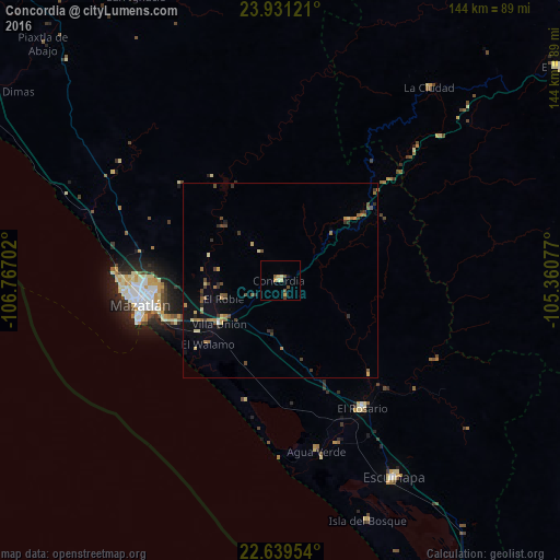
Analysis of Concordia night lights 2016
Square area 10x10 km:
 0%
0%90-99
0.95%80-89
1.33%70-79
2.27%60-69
0%50-59
1.52%40-49
1.7%30-39
0.57%20-29
0%10-19
1.14%0-9
90.53%Square area 50x50 km:
0.02%90-99
0.14%80-89
0.38%70-79
0.38%60-69
0.46%50-59
0.47%40-49
0.62%30-39
0.59%20-29
0.33%10-19
0.82%0-9
95.78%Clear (daylight) street map image can be seen on geolist.org.
Map coordinates:
23° 55' 52.4" North, 106° 46' 1.3" West
23° 17' 13" North, 106° 3' 50" West
22° 38' 22.3" North, 105° 21' 38.8" West
Some cities around Concordia sort by population:
• Mazatlán
35.5 km =22.1 mi,  260°
260°
• Escuinapa
58.4 km =36.3 mi,  149°
149°
• El Salto
90 km =55.9 mi,  52°
52°
• Pueblo Nuevo
70.3 km =43.7 mi,  81°
81°
• El Rosario
39 km =24.2 mi, 147°
• Villa Unión
19.2 km =11.9 mi,  235°
235°
• Fraccionamiento los Ángeles
29.3 km =18.2 mi,  248°
248°
• Isla del Bosque
65.5 km =40.7 mi,  160°
160°
3976324 (p: 8,328)
Sources (retrieved 2019-11-25):
» Earth at Night: Flat Maps 2012, 2016