Tarímbaro night lights from space
Night Light of Tarímbaro (Michoacán) from space (Mexico) Src. Average luminocity for 10x10km area is 41.9752% and for 50x50km: 16.4745%.
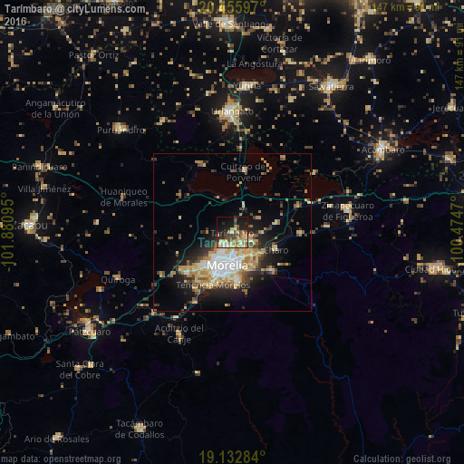
Analysis of Tarímbaro night lights 2016
Square area 10x10 km:
 0.62%
0.62%90-99
5.99%80-89
9.5%70-79
8.26%60-69
10.54%50-59
4.96%40-49
8.68%30-39
3.51%20-29
12.6%10-19
22.11%0-9
13.22%Square area 50x50 km:
1.93%90-99
2.45%80-89
2.9%70-79
2.48%60-69
2.83%50-59
1.53%40-49
2.6%30-39
2.17%20-29
4.3%10-19
7.51%0-9
69.29%Clear (daylight) street map image can be seen on geolist.org.
Map coordinates:
20° 27' 21.5" North, 101° 52' 51.4" West
19° 47' 44.8" North, 101° 10' 40.2" West
19° 7' 58.2" North, 100° 28' 28.9" West
Some cities around Tarímbaro sort by population:
• Morelia
10.6 km =6.6 mi,  183°
183°
• Morelos
17.5 km =10.9 mi,  201°
201°
• Álvaro Obregón
14.7 km =9.1 mi,  79°
79°
• Fraccionamiento Misión del Valle
6.8 km =4.2 mi,  119°
119°
• La Aldea
7.4 km =4.6 mi,  142°
142°
• Fraccionamiento Galaxia Tarímbaro
4.2 km =2.6 mi, 204°
• Fraccionamiento Metrópolis II
5.2 km =3.2 mi,  212°
212°
• Charo
14.7 km =9.1 mi,  110°
110°
11962662 (p: 6,049)
Sources (retrieved 2019-11-25):
» Earth at Night: Flat Maps 2012, 2016