Gutiérrez Zamora night lights from space
Night Light of Gutiérrez Zamora (Veracruz) from space (Mexico) Src. Average luminocity for 10x10km area is 5.9545% and for 50x50km: 2.692%.
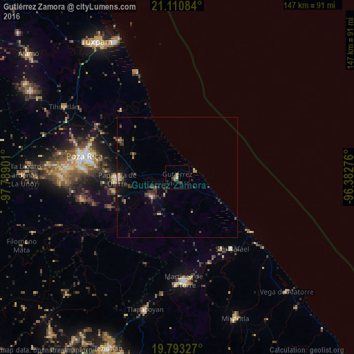
Analysis of Gutiérrez Zamora night lights 2016
Square area 10x10 km:
 0%
0%90-99
0%80-89
0.76%70-79
0.76%60-69
2.27%50-59
0%40-49
2.27%30-39
0.95%20-29
2.27%10-19
0.76%0-9
89.96%Square area 50x50 km:
0.04%90-99
0.2%80-89
0.26%70-79
0.13%60-69
0.46%50-59
0.31%40-49
0.99%30-39
0.71%20-29
0.93%10-19
1.65%0-9
94.32%Clear (daylight) street map image can be seen on geolist.org.
Map coordinates:
21° 6' 39" North, 97° 47' 20.4" West
20° 27' 12.5" North, 97° 5' 9.2" West
19° 47' 35.8" North, 96° 22' 57.9" West
Some cities around Gutiérrez Zamora sort by population:
• Poza Rica de Hidalgo
39.9 km =24.8 mi,  282°
282°
• Martínez de la Torre
42.6 km =26.5 mi,  176°
176°
• Papantla de Olarte
24.9 km =15.5 mi,  268°
268°
• Coatzintla
40 km =24.9 mi, 275°
• Plan de Ayala
41.5 km =25.8 mi, 284°
• Totolapa
42.3 km =26.3 mi,  285°
285°
• San Rafael
37.2 km =23.1 mi,  142°
142°
• Agua Dulce
23.8 km =14.8 mi,  245°
245°
3527186 (p: 13,651)
Sources (retrieved 2019-11-25):
» Earth at Night: Flat Maps 2012, 2016