Agua Dulce night lights from space
Night Light of Agua Dulce (Veracruz) from space (Mexico) Src. Average luminocity for 10x10km area is 9.4489% and for 50x50km: 11.6543%.
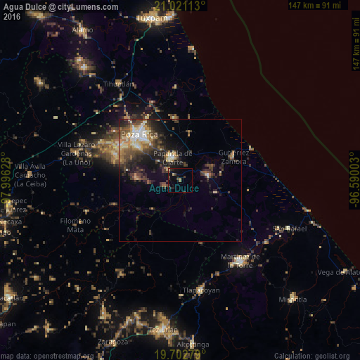
Analysis of Agua Dulce night lights 2016
Square area 10x10 km:
 0%
0%90-99
0%80-89
1.7%70-79
0.38%60-69
1.7%50-59
0.76%40-49
3.98%30-39
2.27%20-29
2.65%10-19
7.77%0-9
78.79%Square area 50x50 km:
0.84%90-99
1.36%80-89
1.76%70-79
1.09%60-69
1.83%50-59
1.6%40-49
3.16%30-39
3.13%20-29
4.02%10-19
6.17%0-9
75.03%Clear (daylight) street map image can be seen on geolist.org.
Map coordinates:
21° 1' 16.1" North, 97° 59' 46.6" West
20° 21' 48.1" North, 97° 17' 35.3" West
19° 42' 10" North, 96° 35' 24.1" West
Some cities around Agua Dulce sort by population:
• Poza Rica de Hidalgo
25.6 km =15.9 mi,  317°
317°
• Martínez de la Torre
40.6 km =25.2 mi,  143°
143°
• Papantla de Olarte
9.8 km =6.1 mi,  340°
340°
• Coatzintla
22.8 km =14.2 mi,  306°
306°
• Gutiérrez Zamora
23.8 km =14.8 mi,  65°
65°
• Plan de Ayala
27.7 km =17.2 mi, 318°
• Coyutla
40.2 km =25 mi,  251°
251°
• Totolapa
28.9 km =18 mi, 318°
3533268 (p: 5,910)
Sources (retrieved 2019-11-25):
» Earth at Night: Flat Maps 2012, 2016