El Colomo night lights from space
Night Light of El Colomo (Colima) from space (Mexico) Src. Average luminocity for 10x10km area is 54.6212% and for 50x50km: 7.1268%.
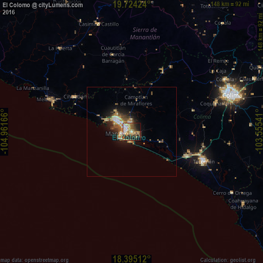
Analysis of El Colomo night lights 2016
Square area 10x10 km:
 6.71%
6.71%90-99
8.87%80-89
7.58%70-79
14.94%60-69
8.23%50-59
6.71%40-49
7.36%30-39
10.82%20-29
17.32%10-19
11.04%0-9
0.43%Square area 50x50 km:
0.71%90-99
0.85%80-89
0.89%70-79
1.37%60-69
1.07%50-59
1.03%40-49
1.4%30-39
1.26%20-29
1.88%10-19
4.12%0-9
85.42%Clear (daylight) street map image can be seen on geolist.org.
Map coordinates:
19° 43' 27.3" North, 104° 57' 42" West
19° 3' 39.6" North, 104° 15' 30.7" West
18° 23' 42.4" North, 103° 33' 19.5" West
Some cities around El Colomo sort by population:
• Manzanillo
10.8 km =6.7 mi,  305°
305°
• Ciudad de Villa de Álvarez
59.3 km =36.8 mi,  67°
67°
• Tecomán
43.1 km =26.8 mi,  111°
111°
• Cihuatlán
37.7 km =23.4 mi,  301°
301°
• Ciudad de Armería
33.8 km =21 mi, 113°
• Coquimatlán
49.9 km =31 mi, 71°
• San Patricio
50.3 km =31.3 mi,  291°
291°
• Cofradía de Juárez
33.7 km =20.9 mi, 108°
4010273 (p: 10,255)
Sources (retrieved 2019-11-25):
» Earth at Night: Flat Maps 2012, 2016