Ciudad de Armería night lights from space
Night Light of Ciudad de Armería (Colima) from space (Mexico) Src. Average luminocity for 10x10km area is 18.8939% and for 50x50km: 3.3475%.
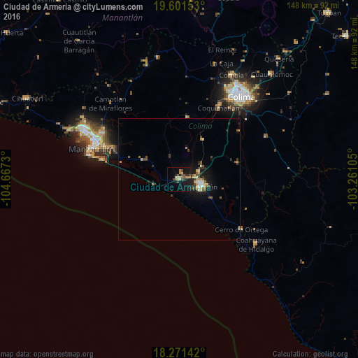
Analysis of Ciudad de Armería night lights 2016
Square area 10x10 km:
 0%
0%90-99
0.43%80-89
4.76%70-79
2.81%60-69
2.81%50-59
3.9%40-49
3.25%30-39
1.52%20-29
3.9%10-19
24.89%0-9
51.73%Square area 50x50 km:
0.12%90-99
0.27%80-89
0.6%70-79
0.52%60-69
0.37%50-59
0.56%40-49
0.57%30-39
0.63%20-29
0.62%10-19
3.07%0-9
92.67%Clear (daylight) street map image can be seen on geolist.org.
Map coordinates:
19° 36' 5.5" North, 104° 40' 2.3" West
18° 56' 16.1" North, 103° 57' 51" West
18° 16' 17.1" North, 103° 15' 39.8" West
Some cities around Ciudad de Armería sort by population:
• Colima
42.7 km =26.5 mi,  35°
35°
• Manzanillo
44.4 km =27.6 mi,  296°
296°
• Tecomán
9.4 km =5.8 mi,  104°
104°
• Coquimatlán
34 km =21.1 mi,  28°
28°
• El Colomo
33.8 km =21 mi,  293°
293°
• Cerro de Ortega
32.9 km =20.4 mi,  129°
129°
• Coahuayana de Hidalgo
41.2 km =25.6 mi, 129°
• Cofradía de Juárez
2.9 km =1.8 mi,  18°
18°
4018227 (p: 15,923)
Sources (retrieved 2019-11-25):
» Earth at Night: Flat Maps 2012, 2016