Coquimatlán night lights from space
Night Light of Coquimatlán (Colima) from space (Mexico) Src. Average luminocity for 10x10km area is 18.8874% and for 50x50km: 7.6491%.
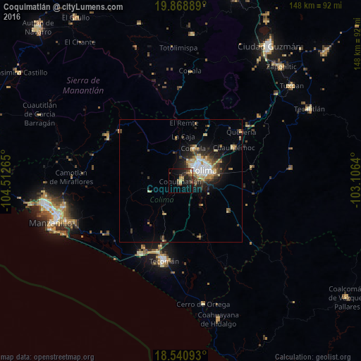
Analysis of Coquimatlán night lights 2016
Square area 10x10 km:
 0.22%
0.22%90-99
0.87%80-89
1.52%70-79
4.55%60-69
4.76%50-59
1.08%40-49
3.03%30-39
5.41%20-29
8.44%10-19
17.32%0-9
52.81%Square area 50x50 km:
1.13%90-99
0.91%80-89
0.96%70-79
1.38%60-69
0.86%50-59
0.69%40-49
1.2%30-39
1.59%20-29
1.96%10-19
4.45%0-9
84.86%Clear (daylight) street map image can be seen on geolist.org.
Map coordinates:
19° 52' 8" North, 104° 30' 45.5" West
19° 12' 22.5" North, 103° 48' 34.3" West
18° 32' 27.3" North, 103° 6' 23" West
Some cities around Coquimatlán sort by population:
• Colima
9.9 km =6.2 mi,  60°
60°
• Ciudad de Villa de Álvarez
10.1 km =6.3 mi,  48°
48°
• Tecomán
33 km =20.5 mi,  192°
192°
• Ciudad de Armería
34 km =21.1 mi,  208°
208°
• Comala
14.4 km =8.9 mi,  21°
21°
• Quesería
32 km =19.9 mi, 51°
• Cuauhtémoc
25.6 km =15.9 mi, 57°
• Cofradía de Juárez
31.1 km =19.3 mi, 209°
4012905 (p: 13,358)
Sources (retrieved 2019-11-25):
» Earth at Night: Flat Maps 2012, 2016