Doctor Mora night lights from space
Night Light of Doctor Mora (Guanajuato) from space (Mexico) Src. Average luminocity for 10x10km area is 16.8909% and for 50x50km: 8.7532%.
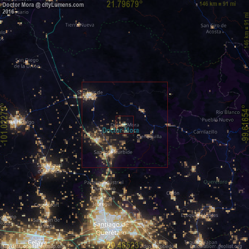
Analysis of Doctor Mora night lights 2016
Square area 10x10 km:
 0.6%
0.6%90-99
0.4%80-89
0.6%70-79
2.78%60-69
3.37%50-59
2.58%40-49
5.56%30-39
3.97%20-29
6.15%10-19
14.68%0-9
59.33%Square area 50x50 km:
0.34%90-99
0.46%80-89
0.89%70-79
1.28%60-69
1.32%50-59
1.13%40-49
2.54%30-39
2.52%20-29
3.14%10-19
8.11%0-9
78.27%Clear (daylight) street map image can be seen on geolist.org.
Map coordinates:
21° 47' 48.4" North, 101° 1' 22" West
21° 8' 32.9" North, 100° 19' 10.8" West
20° 29' 6.8" North, 99° 36' 59.5" West
Some cities around Doctor Mora sort by population:
• San Miguel de Allende
50.8 km =31.6 mi,  240°
240°
• San Luis de la Paz
26.8 km =16.7 mi,  310°
310°
• San José Iturbide
17 km =10.6 mi,  203°
203°
• Santa Rosa Jauregui
46.6 km =29 mi, 196°
• Juriquilla
49.8 km =30.9 mi, 196°
• Colón
48.7 km =30.3 mi,  145°
145°
• Misión de Chichimecas
23.5 km =14.6 mi, 312°
• Amazcala
49.1 km =30.5 mi,  173°
173°
4022983 (p: 5,140)
Sources (retrieved 2019-11-25):
» Earth at Night: Flat Maps 2012, 2016