Amazcala night lights from space
Night Light of Amazcala (Querétaro) from space (Mexico) Src. Average luminocity for 10x10km area is 29.1004% and for 50x50km: 34.8997%.
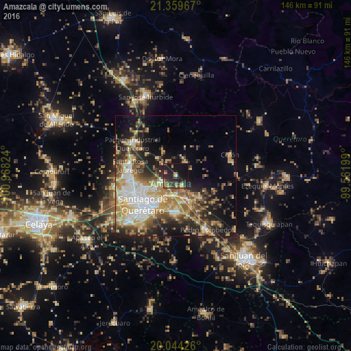
Analysis of Amazcala night lights 2016
Square area 10x10 km:
 0%
0%90-99
0.76%80-89
2.84%70-79
7.01%60-69
3.03%50-59
4.73%40-49
7.77%30-39
8.9%20-29
18.18%10-19
33.9%0-9
12.88%Square area 50x50 km:
5.73%90-99
4.84%80-89
6.11%70-79
6.31%60-69
5.56%50-59
4.25%40-49
5.67%30-39
4.71%20-29
7.75%10-19
12.13%0-9
36.93%Clear (daylight) street map image can be seen on geolist.org.
Map coordinates:
21° 21' 34.8" North, 100° 58' 5.7" West
20° 42' 12.2" North, 100° 15' 54.4" West
20° 2' 39.3" North, 99° 33' 43.2" West
Some cities around Amazcala sort by population:
• Santiago de Querétaro
18.1 km =11.2 mi,  224°
224°
• Santa Rosa Jauregui
19.5 km =12.1 mi,  282°
282°
• Venceremos
21.9 km =13.6 mi, 219°
• San José el Alto
13.4 km =8.3 mi,  245°
245°
• Juriquilla
19.8 km =12.3 mi,  273°
273°
• La Cañada
12.7 km =7.9 mi,  213°
213°
• La Pradera
9.4 km =5.8 mi,  238°
238°
• Saldarriaga
8.9 km =5.5 mi,  199°
199°
4018601 (p: 5,768)
Sources (retrieved 2019-11-25):
» Earth at Night: Flat Maps 2012, 2016