Estación Queréndaro night lights from space
Night Light of Estación Queréndaro (Michoacán) from space (Mexico) Src. Average luminocity for 10x10km area is 9.8636% and for 50x50km: 11.7443%.
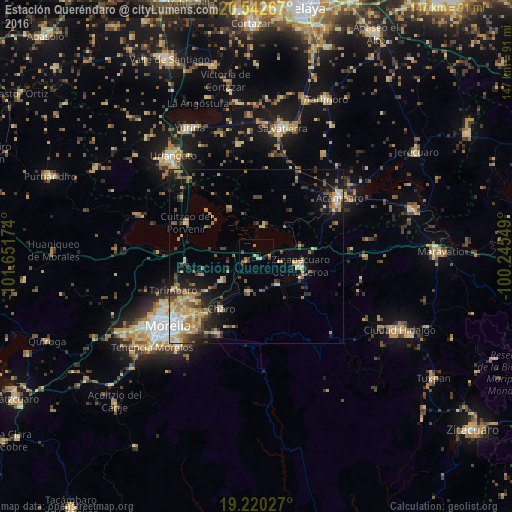
Analysis of Estación Queréndaro night lights 2016
Square area 10x10 km:
 0%
0%90-99
0.43%80-89
1.73%70-79
2.16%60-69
2.16%50-59
0.43%40-49
2.38%30-39
1.52%20-29
2.6%10-19
1.3%0-9
85.28%Square area 50x50 km:
0.65%90-99
1.17%80-89
2.25%70-79
1.97%60-69
2.37%50-59
1.2%40-49
2.25%30-39
1.84%20-29
2.36%10-19
5.53%0-9
78.4%Clear (daylight) street map image can be seen on geolist.org.
Map coordinates:
20° 32' 33.6" North, 101° 39' 6.3" West
19° 52' 58.3" North, 100° 56' 55" West
19° 13' 13" North, 100° 14' 43.8" West
Some cities around Estación Queréndaro sort by population:
• Zinapécuaro
12.8 km =8 mi,  101°
101°
• Queréndaro
10.2 km =6.3 mi,  143°
143°
• Álvaro Obregón
11.8 km =7.3 mi,  234°
234°
• Fraccionamiento Misión del Valle
22.3 km =13.9 mi, 234°
• Santa Ana Maya
15.8 km =9.8 mi,  330°
330°
• Indaparapeo
10.8 km =6.7 mi,  191°
191°
• Irámuco
9.2 km =5.7 mi,  17°
17°
• Charo
18 km =11.2 mi,  214°
214°
3991169 (p: 8,770)
Sources (retrieved 2019-11-25):
» Earth at Night: Flat Maps 2012, 2016