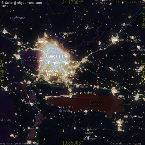
El Salto night lights from space
Night Light of El Salto (Jalisco) from space (Mexico) Src. Average luminocity for 10x10km area is 61.7538% and for 50x50km: 40.4598%.

Analysis of El Salto night lights 2016
Square area 10x10 km:
 3.79%
3.79%90-99
6.63%80-89
18.37%70-79
13.07%60-69
17.61%50-59
11.17%40-49
6.63%30-39
9.47%20-29
7.58%10-19
5.68%0-9
0%Square area 50x50 km:
12.16%90-99
6.57%80-89
6.98%70-79
5.55%60-69
3.85%50-59
3.43%40-49
5.06%30-39
4.25%20-29
5.21%10-19
10.33%0-9
36.61%Clear (daylight) street map image can be seen on geolist.org.
Map coordinates:
21° 10' 33.7" North, 103° 53' 5" West
20° 31' 8.2" North, 103° 10' 53.7" West
19° 51' 32.5" North, 102° 28' 42.5" West
Some cities around El Salto sort by population:
• San José del Castillo
5.9 km =3.7 mi,  264°
264°
• Centro de Readaptación Social
4.1 km =2.5 mi,  342°
342°
• Juanacatlán
1.6 km =1 mi,  133°
133°
• Galaxia Bonito Jalisco
2.9 km =1.8 mi,  237°
237°
• La Alameda
7.4 km =4.6 mi,  249°
249°
• Capulín
10.2 km =6.3 mi, 243°
• Rancho Alegre [Fraccionamiento]
9.4 km =5.8 mi, 237°
• Puente Grande
6.3 km =3.9 mi,  27°
27°
4007682 (p: 21,644)
Sources (retrieved 2019-11-25):
» Earth at Night: Flat Maps 2012, 2016