Juanacatlán night lights from space
Night Light of Juanacatlán (Jalisco) from space (Mexico) Src. Average luminocity for 10x10km area is 52.8409% and for 50x50km: 39.283%.
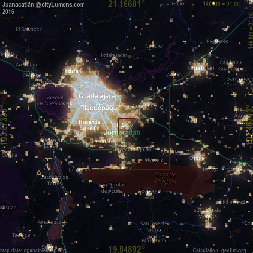
Analysis of Juanacatlán night lights 2016
Square area 10x10 km:
 2.46%
2.46%90-99
4.92%80-89
12.69%70-79
9.47%60-69
14.02%50-59
11.55%40-49
9.28%30-39
11.17%20-29
11.55%10-19
11.74%0-9
1.14%Square area 50x50 km:
11.44%90-99
6.19%80-89
6.73%70-79
5.54%60-69
3.91%50-59
3.48%40-49
5.21%30-39
4.19%20-29
5.16%10-19
10.33%0-9
37.81%Clear (daylight) street map image can be seen on geolist.org.
Map coordinates:
21° 9' 57.6" North, 103° 52' 24.2" West
20° 30' 32" North, 103° 10' 12.9" West
19° 50' 56.1" North, 102° 28' 1.7" West
Some cities around Juanacatlán sort by population:
• El Salto
1.6 km =1 mi,  313°
313°
• San José del Castillo
7.1 km =4.4 mi,  274°
274°
• Centro de Readaptación Social
5.6 km =3.5 mi,  334°
334°
• Galaxia Bonito Jalisco
3.6 km =2.2 mi,  263°
263°
• La Alameda
8.3 km =5.2 mi, 259°
• Rancho Alegre [Fraccionamiento]
9.9 km =6.2 mi,  246°
246°
• Los Olivos
10.5 km =6.5 mi,  222°
222°
• Puente Grande
7 km =4.3 mi,  14°
14°
4003810 (p: 9,133)
Sources (retrieved 2019-11-25):
» Earth at Night: Flat Maps 2012, 2016