Anáhuac night lights from space
Night Light of Anáhuac (Chihuahua) from space (Mexico) Src. Average luminocity for 10x10km area is 15.1587% and for 50x50km: 5.5844%.
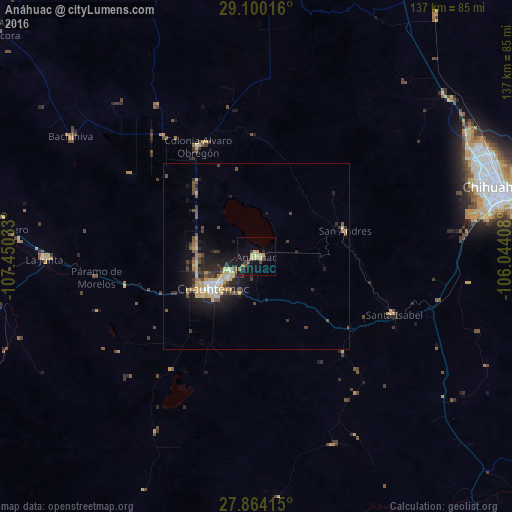
Analysis of Anáhuac night lights 2016
Square area 10x10 km:
 0%
0%90-99
0%80-89
7.74%70-79
1.59%60-69
0.99%50-59
1.19%40-49
1.98%30-39
1.59%20-29
1.59%10-19
12.9%0-9
70.44%Square area 50x50 km:
0.31%90-99
0.43%80-89
1.32%70-79
0.99%60-69
0.32%50-59
0.73%40-49
1.22%30-39
0.77%20-29
1.82%10-19
4.38%0-9
87.73%Clear (daylight) street map image can be seen on geolist.org.
Map coordinates:
29° 6' 0.6" North, 107° 27' 1.2" West
28° 29' 2.3" North, 106° 44' 49.9" West
27° 51' 50.9" North, 106° 2' 38.7" West
Some cities around Anáhuac sort by population:
• Chihuahua
66.5 km =41.3 mi,  75°
75°
• Cuauhtémoc
14.1 km =8.8 mi,  233°
233°
• Aldama
90.2 km =56 mi,  64°
64°
• La Junta
56.9 km =35.4 mi,  269°
269°
• Adolfo López Mateos
54.1 km =33.6 mi, 267°
• Guerrero
72.3 km =44.9 mi,  275°
275°
• Santa Eulalia
84.8 km =52.7 mi, 81°
• Valentín Gómez Farías
33.8 km =21 mi,  151°
151°
4018543 (p: 9,952)
Sources (retrieved 2019-11-25):
» Earth at Night: Flat Maps 2012, 2016