Aldama night lights from space
Night Light of Aldama (Chihuahua) from space (Mexico) Src. Average luminocity for 10x10km area is 17.1534% and for 50x50km: 12.7463%.
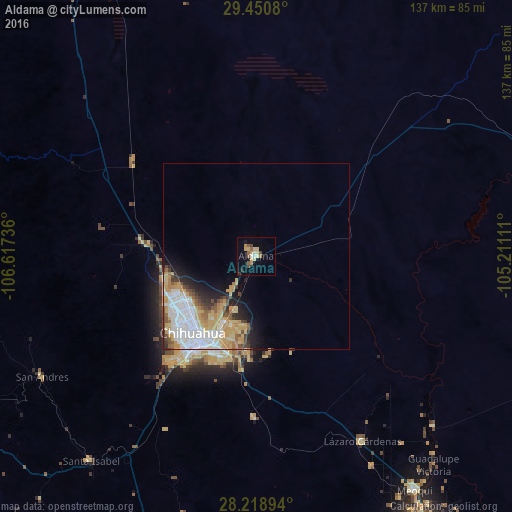
Analysis of Aldama night lights 2016
Square area 10x10 km:
 1.52%
1.52%90-99
0.76%80-89
5.3%70-79
2.65%60-69
1.33%50-59
3.41%40-49
2.46%30-39
0.76%20-29
0.76%10-19
6.25%0-9
74.81%Square area 50x50 km:
3.58%90-99
2.2%80-89
2.14%70-79
2.59%60-69
0.84%50-59
1.14%40-49
1.2%30-39
0.97%20-29
1.52%10-19
3.32%0-9
80.5%Clear (daylight) street map image can be seen on geolist.org.
Map coordinates:
29° 27' 2.9" North, 106° 37' 2.5" West
28° 50' 12.1" North, 105° 54' 51.2" West
28° 13' 8.2" North, 105° 12' 40" West
Some cities around Aldama sort by population:
• Chihuahua
28.1 km =17.5 mi,  217°
217°
• Ciudad Delicias
84 km =52.2 mi,  148°
148°
• Jiménez
75.2 km =46.7 mi,  138°
138°
• Meoqui
75.7 km =47 mi, 145°
• Lázaro Cárdenas
57.2 km =35.5 mi, 150°
• Ampliación Colonia Lázaro Cárdenas
58.2 km =36.2 mi, 150°
• Santa Eulalia
27.1 km =16.8 mi,  174°
174°
• Rosales
80.2 km =49.8 mi, 154°
4018831 (p: 18,642)
Sources (retrieved 2019-11-25):
» Earth at Night: Flat Maps 2012, 2016