San Miguel Contla night lights from space
Night Light of San Miguel Contla (Tlaxcala) from space (Mexico) Src. Average luminocity for 10x10km area is 77.6901% and for 50x50km: 33.6333%.
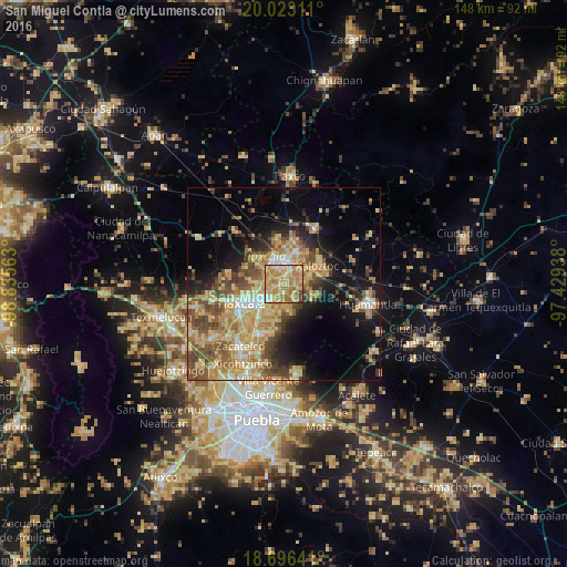
Analysis of San Miguel Contla night lights 2016
Square area 10x10 km:
 5.79%
5.79%90-99
7.85%80-89
31.61%70-79
31.4%60-69
18.18%50-59
2.07%40-49
2.69%30-39
0.41%20-29
0%10-19
0%0-9
0%Square area 50x50 km:
1.83%90-99
3.16%80-89
9.88%70-79
7.28%60-69
6.03%50-59
5.16%40-49
6.73%30-39
3.62%20-29
4.65%10-19
11.5%0-9
40.16%Clear (daylight) street map image can be seen on geolist.org.
Map coordinates:
20° 1' 23.2" North, 98° 50' 8.3" West
19° 21' 40" North, 98° 7' 57" West
18° 41' 47.1" North, 97° 25' 45.8" West
Some cities around San Miguel Contla sort by population:
• Apizaco
5.9 km =3.7 mi,  348°
348°
• Contla
5 km =3.1 mi,  225°
225°
• San Andrés Ahuashuatepec
3.3 km =2.1 mi,  54°
54°
• Amaxac de Guerrero
4.3 km =2.7 mi,  248°
248°
• Santa Anita Huiloac
3.3 km =2.1 mi,  338°
338°
• Apetatitlán Antonio Carbajal
5.6 km =3.5 mi,  240°
240°
• San Luis Apizaquito
7.3 km =4.5 mi,  12°
12°
• San Benito Xaltocan
6.1 km =3.8 mi,  324°
324°
3518230 (p: 5,761)
Sources (retrieved 2019-11-25):
» Earth at Night: Flat Maps 2012, 2016