Coxcatlán night lights from space
Night Light of Coxcatlán (Puebla) from space (Mexico) Src. Average luminocity for 10x10km area is 4.8616% and for 50x50km: 4.8238%.
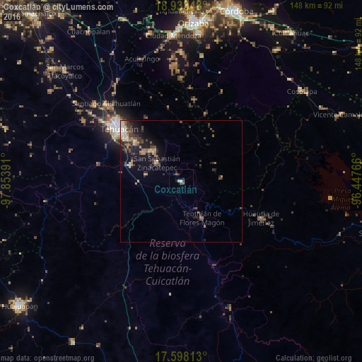
Analysis of Coxcatlán night lights 2016
Square area 10x10 km:
 0%
0%90-99
0.62%80-89
1.03%70-79
0%60-69
1.03%50-59
0.62%40-49
1.03%30-39
2.69%20-29
0.62%10-19
1.45%0-9
90.91%Square area 50x50 km:
0.24%90-99
0.33%80-89
0.79%70-79
0.76%60-69
0.6%50-59
0.63%40-49
1.12%30-39
1.41%20-29
1.49%10-19
3.64%0-9
89%Clear (daylight) street map image can be seen on geolist.org.
Map coordinates:
18° 56' 0.5" North, 97° 51' 14.1" West
18° 16' 1.5" North, 97° 9' 2.8" West
17° 35' 53.3" North, 96° 26' 51.6" West
Some cities around Coxcatlán sort by population:
• Tehuacán
34 km =21.1 mi,  310°
310°
• Ajalpan
16.9 km =10.5 mi,  317°
317°
• Altepexi
19.5 km =12.1 mi, 306°
• Zinacatepec
12.6 km =7.8 mi, 306°
• San Gabriel Chilac
21.7 km =13.5 mi,  287°
287°
• Huautla de Jiménez
36 km =22.4 mi,  114°
114°
• Miahuatlán
14.7 km =9.1 mi,  280°
280°
• Teotitlán
17.3 km =10.7 mi,  150°
150°
3530150 (p: 6,300)
Sources (retrieved 2019-11-25):
» Earth at Night: Flat Maps 2012, 2016