Zinacatepec night lights from space
Night Light of Zinacatepec (Puebla) from space (Mexico) Src. Average luminocity for 10x10km area is 18.6839% and for 50x50km: 8.4366%.
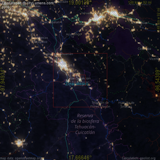
Analysis of Zinacatepec night lights 2016
Square area 10x10 km:
 0.41%
0.41%90-99
0.62%80-89
3.1%70-79
3.1%60-69
3.51%50-59
3.1%40-49
2.69%30-39
4.13%20-29
5.79%10-19
17.56%0-9
55.99%Square area 50x50 km:
0.75%90-99
0.87%80-89
1.28%70-79
1.1%60-69
1.06%50-59
1%40-49
1.83%30-39
2.09%20-29
2.93%10-19
6.2%0-9
80.9%Clear (daylight) street map image can be seen on geolist.org.
Map coordinates:
19° 0' 4.6" North, 97° 56' 57.6" West
18° 20' 6.6" North, 97° 14' 46.4" West
17° 39' 59.3" North, 96° 32' 35.1" West
Some cities around Zinacatepec sort by population:
• Tehuacán
21.5 km =13.4 mi,  311°
311°
• Ajalpan
5.1 km =3.2 mi,  344°
344°
• Altepexi
6.9 km =4.3 mi,  304°
304°
• Miahuatlán
31.4 km =19.5 mi,  319°
319°
• San Gabriel Chilac
10.7 km =6.6 mi,  264°
264°
• Miahuatlán
6.5 km =4 mi,  222°
222°
• Teotitlán
29.2 km =18.1 mi,  140°
140°
• Coxcatlán
12.6 km =7.8 mi,  126°
126°
3517795 (p: 15,592)
Sources (retrieved 2019-11-25):
» Earth at Night: Flat Maps 2012, 2016