Coyutla night lights from space
Night Light of Coyutla (Veracruz) from space (Mexico) Src. Average luminocity for 10x10km area is 4.8909% and for 50x50km: 5.4892%.
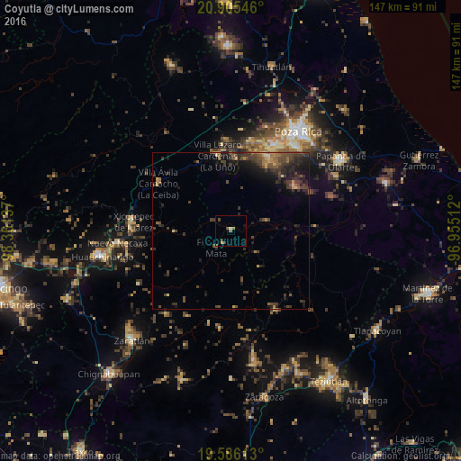
Analysis of Coyutla night lights 2016
Square area 10x10 km:
 0%
0%90-99
0%80-89
0.79%70-79
0.99%60-69
0.6%50-59
1.39%40-49
1.98%30-39
1.59%20-29
0%10-19
0.79%0-9
91.87%Square area 50x50 km:
0.02%90-99
0.09%80-89
0.45%70-79
0.61%60-69
0.89%50-59
0.96%40-49
2.28%30-39
2.29%20-29
2.33%10-19
3.65%0-9
86.44%Clear (daylight) street map image can be seen on geolist.org.
Map coordinates:
20° 54' 19.7" North, 98° 21' 40.9" West
20° 14' 49.9" North, 97° 39' 29.7" West
19° 35' 10.1" North, 96° 57' 18.4" West
Some cities around Coyutla sort by population:
• Xicotepec de Juárez
31.8 km =19.8 mi,  275°
275°
• Filomeno Mata
7.1 km =4.4 mi,  222°
222°
• Villa Lázaro Cárdenas
24.3 km =15.1 mi,  349°
349°
• Villa Avila Camacho
27.8 km =17.3 mi,  303°
303°
• Venustiano Carranza
28.9 km =18 mi,  357°
357°
• Ciudad de Cuetzalan
29.2 km =18.1 mi,  150°
150°
• Cuetzalan
29.2 km =18.1 mi, 151°
• Mecatlán
4.8 km =3 mi,  211°
211°
3530110 (p: 8,413)
Sources (retrieved 2019-11-25):
» Earth at Night: Flat Maps 2012, 2016