Dar Naim night lights from space
Night Light of Dar Naim (Nouakchott Nord) from space (Mauritania) Src. Average luminocity for 10x10km area is 64.6017% and for 50x50km: 7.5658%.
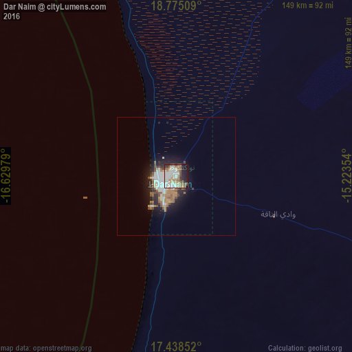
Analysis of Dar Naim night lights 2016
Square area 10x10 km:
 17.1%
17.1%90-99
17.53%80-89
6.93%70-79
6.93%60-69
8.23%50-59
11.69%40-49
4.76%30-39
3.03%20-29
9.96%10-19
12.77%0-9
1.08%Square area 50x50 km:
1.28%90-99
1.76%80-89
0.56%70-79
0.55%60-69
1.38%50-59
1.38%40-49
0.9%30-39
0.61%20-29
1.85%10-19
4.35%0-9
85.37%Clear (daylight) street map image can be seen on geolist.org.
Map coordinates:
18° 46' 30.3" North, 16° 37' 47.2" West
18° 6' 29.1" North, 15° 55' 36" West
17° 26' 18.7" North, 15° 13' 24.7" West
Some cities around Dar Naim sort by population:
• Nouakchott
6 km =3.7 mi,  245°
245°
• Rosso
177.7 km =110.4 mi,  175°
175°
• Richard-Toll, SN
184.5 km =114.6 mi,  172°
172°
• Tékane
178.4 km =110.9 mi,  159°
159°
• Ndioum, SN
223.4 km =138.8 mi,  142°
142°
• Rosso, SN
188.2 km =116.9 mi, 175°
• Arafat
8.4 km =5.2 mi,  214°
214°
• Tevragh Zeina
6.6 km =4.1 mi,  261°
261°
11496397 (p: 0)
Sources (retrieved 2019-11-25):
» Earth at Night: Flat Maps 2012, 2016