Kotor night lights from space
Night Light of Kotor from space (Montenegro) Src. Average luminocity for 10x10km area is 22.8079% and for 50x50km: 4.9982%.
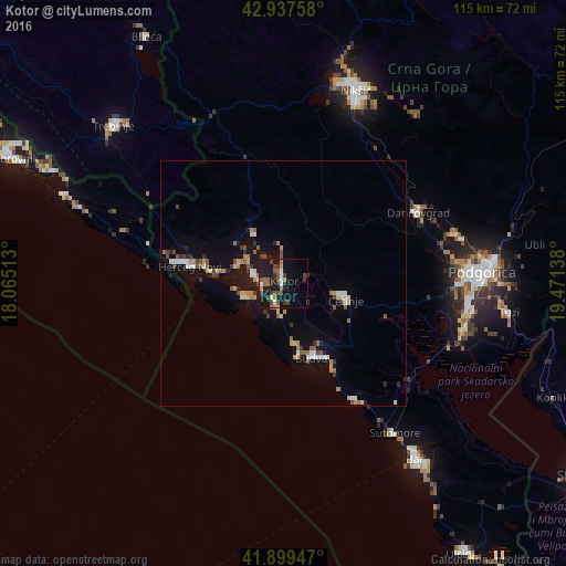
Analysis of Kotor night lights 2016
Square area 10x10 km:
100  1.75%
1.75%
90-99 2.86%
80-89 0.48%
70-79 1.9%
60-69 4.44%
50-59 5.4%
40-49 4.13%
30-39 5.4%
20-29 3.17%
10-19 30.48%
0-9 40%
1.75%90-99
2.86%80-89
0.48%70-79
1.9%60-69
4.44%50-59
5.4%40-49
4.13%30-39
5.4%20-29
3.17%10-19
30.48%0-9
40%Square area 50x50 km:
100 0.42%
90-99 0.71%
80-89 0.4%
70-79 0.65%
60-69 0.63%
50-59 0.88%
40-49 0.67%
30-39 0.67%
20-29 0.61%
10-19 4.05%
0-9 90.31%
0.42%90-99
0.71%80-89
0.4%70-79
0.65%60-69
0.63%50-59
0.88%40-49
0.67%30-39
0.67%20-29
0.61%10-19
4.05%0-9
90.31%Clear (daylight) street map image can be seen on geolist.org.
Map coordinates:
42° 56' 15.3" North, 18° 3' 54.5" East
42° 25' 14.4" North, 18° 46' 5.7" East
41° 53' 58.1" North, 19° 28' 17" East
Some cities around Kotor sort by population:
• Podgorica
40.7 km =25.3 mi,  86°
86°
• Nikšić
41.8 km =26 mi,  20°
20°
• Herceg-Novi
19.3 km =12 mi,  280°
280°
• Budva
16.1 km =10 mi,  158°
158°
• Cetinje
12.4 km =7.7 mi,  105°
105°
• Tivat
6.4 km =4 mi,  285°
285°
• Dobrota
3.7 km =2.3 mi,  0°
0°
• Danilovgrad
34.3 km =21.3 mi,  64°
64°
3197538 (p: 5,345)
Sources (retrieved 2019-11-25):
» Earth at Night: Flat Maps 2012, 2016