Dobrota night lights from space
Night Light of Dobrota (Kotor) from space (Montenegro) Src. Average luminocity for 10x10km area is 18.8381% and for 50x50km: 4.814%.
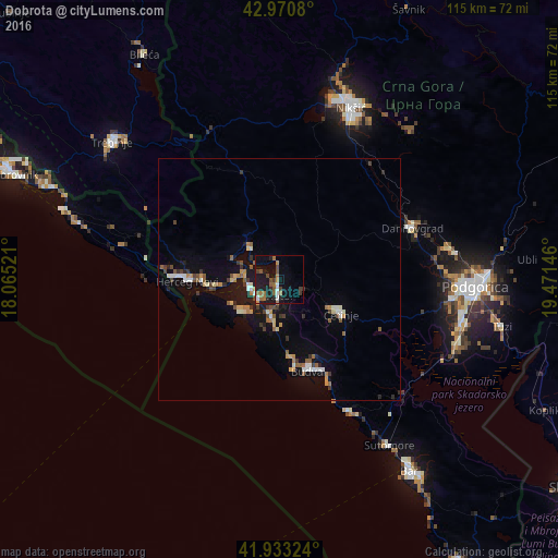
Analysis of Dobrota night lights 2016
Square area 10x10 km:
 1.43%
1.43%90-99
2.06%80-89
0%70-79
1.43%60-69
4.44%50-59
5.08%40-49
3.81%30-39
2.38%20-29
3.17%10-19
22.86%0-9
53.33%Square area 50x50 km:
0.41%90-99
0.67%80-89
0.35%70-79
0.59%60-69
0.6%50-59
0.86%40-49
0.67%30-39
0.7%20-29
0.61%10-19
4.05%0-9
90.49%Clear (daylight) street map image can be seen on geolist.org.
Map coordinates:
42° 58' 14.9" North, 18° 3' 54.8" East
42° 27' 15" North, 18° 46' 6" East
41° 55' 59.7" North, 19° 28' 17.3" East
Some cities around Dobrota sort by population:
• Podgorica
40.7 km =25.3 mi,  92°
92°
• Nikšić
38.3 km =23.8 mi,  22°
22°
• Herceg-Novi
18.9 km =11.7 mi,  269°
269°
• Budva
19.6 km =12.2 mi,  162°
162°
• Cetinje
13.9 km =8.6 mi,  120°
120°
• Tivat
6.4 km =4 mi,  251°
251°
• Kotor
3.7 km =2.3 mi,  180°
180°
• Danilovgrad
32.9 km =20.4 mi,  70°
70°
3201903 (p: 5,435)
Sources (retrieved 2019-11-25):
» Earth at Night: Flat Maps 2012, 2016