Herceg-Novi night lights from space
Night Light of Herceg-Novi (Herceg Novi) from space (Montenegro) Src. Average luminocity for 10x10km area is 18.8889% and for 50x50km: 4.2794%.
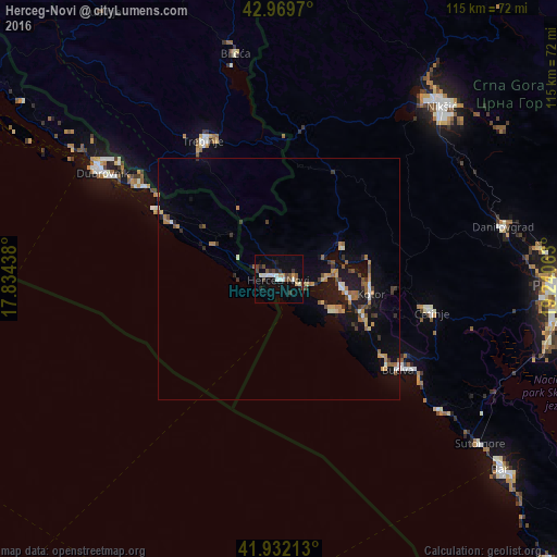
Analysis of Herceg-Novi night lights 2016
Square area 10x10 km:
 2.54%
2.54%90-99
4.13%80-89
0.95%70-79
1.43%60-69
0.63%50-59
2.86%40-49
4.76%30-39
2.86%20-29
3.17%10-19
8.41%0-9
68.25%Square area 50x50 km:
0.28%90-99
0.51%80-89
0.34%70-79
0.54%60-69
0.65%50-59
0.74%40-49
0.63%30-39
0.73%20-29
0.6%10-19
3.78%0-9
91.21%Clear (daylight) street map image can be seen on geolist.org.
Map coordinates:
42° 58' 10.9" North, 17° 50' 3.8" East
42° 27' 11" North, 18° 32' 15" East
41° 55' 55.7" North, 19° 14' 26.3" East
Some cities around Herceg-Novi sort by population:
• Trebinje, BA
32.9 km =20.4 mi,  331°
331°
• Dubrovnik, HR
40.9 km =25.4 mi,  300°
300°
• Budva
31 km =19.3 mi,  126°
126°
• Cetinje
31.7 km =19.7 mi,  102°
102°
• Bileća, BA
47.9 km =29.8 mi,  349°
349°
• Tivat
12.9 km =8 mi, 98°
• Dobrota
18.9 km =11.7 mi,  89°
89°
• Kotor
19.3 km =12 mi, 100°
3199394 (p: 19,536)
Sources (retrieved 2019-11-25):
» Earth at Night: Flat Maps 2012, 2016