Danilovgrad night lights from space
Night Light of Danilovgrad from space (Montenegro) Src. Average luminocity for 10x10km area is 11.627% and for 50x50km: 7.0853%.
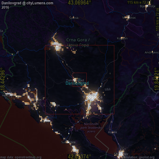
Analysis of Danilovgrad night lights 2016
Square area 10x10 km:
 0.79%
0.79%90-99
2.22%80-89
1.43%70-79
0.63%60-69
1.59%50-59
2.38%40-49
0.95%30-39
2.22%20-29
3.81%10-19
1.11%0-9
82.86%Square area 50x50 km:
1.01%90-99
1.4%80-89
0.52%70-79
0.59%60-69
0.82%50-59
1.19%40-49
0.93%30-39
1.13%20-29
2.2%10-19
4.98%0-9
85.23%Clear (daylight) street map image can be seen on geolist.org.
Map coordinates:
43° 4' 10.7" North, 18° 26' 34.7" East
42° 33' 13.8" North, 19° 8' 45.9" East
42° 2' 1.5" North, 19° 50' 57.2" East
Some cities around Danilovgrad sort by population:
• Podgorica
15.8 km =9.8 mi,  142°
142°
• Nikšić
29.4 km =18.3 mi,  325°
325°
• Budva
38.9 km =24.2 mi,  220°
220°
• Cetinje
26.3 km =16.3 mi,  226°
226°
• Tivat
39.3 km =24.4 mi,  250°
250°
• Dobrota
32.9 km =20.4 mi, 250°
• Kotor
34.3 km =21.3 mi,  244°
244°
• Kolašin
42.5 km =26.4 mi,  45°
45°
3202194 (p: 5,208)
Sources (retrieved 2019-11-25):
» Earth at Night: Flat Maps 2012, 2016