Oualidia night lights from space
Night Light of Oualidia (Casablanca-Settat) from space (Morocco) Src. Average luminocity for 10x10km area is 5.6189% and for 50x50km: 0.3742%.
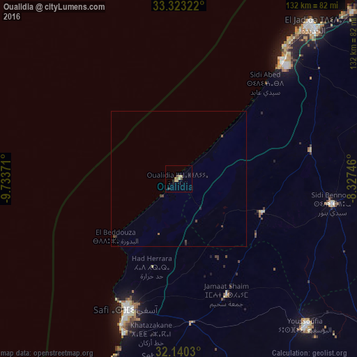
Analysis of Oualidia night lights 2016
Square area 10x10 km:
 0%
0%90-99
0%80-89
1.92%70-79
1.57%60-69
0.87%50-59
0.52%40-49
1.22%30-39
0.87%20-29
0.52%10-19
0.87%0-9
91.61%Square area 50x50 km:
0%90-99
0%80-89
0.08%70-79
0.07%60-69
0.07%50-59
0.05%40-49
0.17%30-39
0.1%20-29
0.09%10-19
0.04%0-9
99.33%Clear (daylight) street map image can be seen on geolist.org.
Map coordinates:
33° 19' 23.6" North, 9° 44' 1.4" West
32° 44' 1.4" North, 9° 1' 50.1" West
32° 8' 25.1" North, 8° 19' 38.9" West
Some cities around Oualidia sort by population:
• Safi
52 km =32.3 mi,  201°
201°
• El Jadid
75.8 km =47.1 mi,  39°
39°
• Settat
135.4 km =84.1 mi,  77°
77°
• Berrechid
147 km =91.3 mi,  66°
66°
• Youssoufia
71.7 km =44.6 mi,  139°
139°
• Sidi Bennour
57.1 km =35.5 mi,  99°
99°
• Azemmour
89.1 km =55.4 mi,  46°
46°
• Zawyat an Nwaçer
149.9 km =93.1 mi,  61°
61°
2541068 (p: 5,826)
Sources (retrieved 2019-11-25):
» Earth at Night: Flat Maps 2012, 2016