Kasba Tadla night lights from space
Night Light of Kasba Tadla (Béni Mellal-Khénifra) from space (Morocco) Src. Average luminocity for 10x10km area is 15.6031% and for 50x50km: 3.389%.
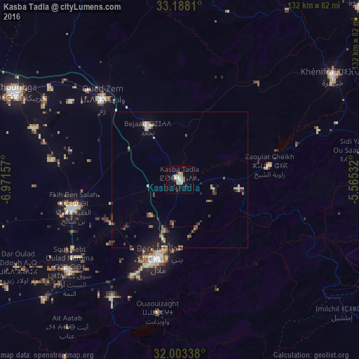

Analysis of Kasba Tadla night lights 2016
Square area 10x10 km:
 1.92%
1.92%90-99
2.27%80-89
3.32%70-79
3.67%60-69
0%50-59
0.7%40-49
0.87%30-39
2.8%20-29
1.22%10-19
3.85%0-9
79.37%Square area 50x50 km:
0.18%90-99
0.29%80-89
0.54%70-79
0.48%60-69
0.42%50-59
0.38%40-49
0.53%30-39
0.65%20-29
0.82%10-19
1.75%0-9
93.96%Clear (daylight) street map image can be seen on geolist.org.
Map coordinates:
33° 11' 17.2" North, 6° 58' 17.7" West
32° 35' 51.7" North, 6° 16' 6.4" West
32° 0' 12.2" North, 5° 33' 55.2" West
Some cities around Kasba Tadla sort by population:
• Khouribga
67.5 km =41.9 mi,  297°
297°
• Beni Mellal
29.9 km =18.6 mi,  194°
194°
• Oued Zem
41 km =25.5 mi,  315°
315°
• Al Fqih Ben Çalah
40.7 km =25.3 mi,  254°
254°
• Khenifra
68 km =42.3 mi,  56°
56°
• Oulmes
95.4 km =59.3 mi,  15°
15°
• Boujniba
58.1 km =36.1 mi,  305°
305°
• Ifrane
99.9 km =62.1 mi,  184°
184°
2544720 (p: 41,199)
Sources (retrieved 2019-11-25):
» Earth at Night: Flat Maps 2012, 2016