Ahfir night lights from space
Night Light of Ahfir (Oriental) from space (Morocco) Src. Average luminocity for 10x10km area is 12.1996% and for 50x50km: 8.2893%.
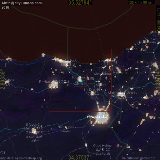
Analysis of Ahfir night lights 2016
Square area 10x10 km:
 1.47%
1.47%90-99
1.83%80-89
2.56%70-79
0.73%60-69
0.73%50-59
1.47%40-49
0.73%30-39
2.38%20-29
2.75%10-19
0%0-9
85.35%Square area 50x50 km:
0.67%90-99
1.17%80-89
1.47%70-79
0.93%60-69
1.08%50-59
0.67%40-49
0.89%30-39
1.11%20-29
1.54%10-19
7.21%0-9
83.25%Clear (daylight) street map image can be seen on geolist.org.
Map coordinates:
35° 31' 40.6" North, 2° 48' 12.2" West
34° 57' 13.2" North, 2° 6' 1" West
34° 22' 31.3" North, 1° 23' 49.7" West
Some cities around Ahfir sort by population:
• Oujda-Angad
35 km =21.7 mi,  149°
149°
• Berkane
20.4 km =12.7 mi,  259°
259°
• Remchi, DZ
61.9 km =38.5 mi,  78°
78°
• Hennaya, DZ
66.7 km =41.4 mi,  90°
90°
• Nedroma, DZ
32.8 km =20.4 mi, 78°
• El Aïoun
55.4 km =34.4 mi,  221°
221°
• Zaïo
57.7 km =35.9 mi,  268°
268°
• Beni Mester, DZ
62.4 km =38.8 mi,  98°
98°
2561124 (p: 19,611)
Sources (retrieved 2019-11-25):
» Earth at Night: Flat Maps 2012, 2016