Nedroma night lights from space
Night Light of Nedroma (Tlemcen) from space (Algeria) Src. Average luminocity for 10x10km area is 13.8409% and for 50x50km: 6.506%.
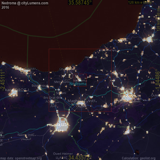

Analysis of Nedroma night lights 2016
Square area 10x10 km:
 0.52%
0.52%90-99
1.75%80-89
2.97%70-79
1.05%60-69
2.8%50-59
1.22%40-49
1.57%30-39
2.27%20-29
3.32%10-19
1.92%0-9
80.59%Square area 50x50 km:
0.38%90-99
0.64%80-89
1.02%70-79
0.94%60-69
0.87%50-59
0.72%40-49
0.75%30-39
1.3%20-29
1%10-19
2.78%0-9
89.61%Clear (daylight) street map image can be seen on geolist.org.
Map coordinates:
35° 35' 14.8" North, 2° 27' 4" West
35° 0' 49" North, 1° 44' 52.8" West
34° 26' 8.6" North, 1° 2' 41.5" West
Some cities around Nedroma sort by population:
• Oujda-Angad, MA
39.7 km =24.7 mi,  201°
201°
• Tlemcen
42.2 km =26.2 mi,  110°
110°
• Mansoûra
40.9 km =25.4 mi, 114°
• Remchi
29.1 km =18.1 mi,  79°
79°
• Hennaya
35.3 km =21.9 mi,  101°
101°
• Chetouane
42.5 km =26.4 mi, 103°
• Beni Mester
33.6 km =20.9 mi,  118°
118°
• Ahfir, MA
32.8 km =20.4 mi,  258°
258°
2486284 (p: 36,995)
Sources (retrieved 2019-11-25):
» Earth at Night: Flat Maps 2012, 2016