Pétange night lights from space
Night Light of Pétange (Esch-sur-Alzette) from space (Luxembourg) Src. Average luminocity for 10x10km area is 53.4958% and for 50x50km: 21.3169%.
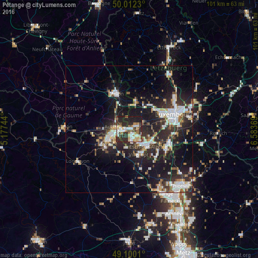
Analysis of Pétange night lights 2016
Square area 10x10 km:
 11.34%
90-99
10.08%80-89
8.96%70-79
6.02%60-69
4.48%50-59
4.76%40-49
8.54%30-39
7.56%20-29
27.17%10-19
11.06%0-9
0%Square area 50x50 km:
4.03%90-99
4.1%80-89
2.05%70-79
1.82%60-69
1.73%50-59
2.22%40-49
2.36%30-39
3.74%20-29
9.35%10-19
16.35%0-9
52.26%Clear (daylight) street map image can be seen on geolist.org.
Map coordinates:
50° 0' 44.3" North, 5° 10' 38.8" East
49° 33' 30" North, 5° 52' 50" East
49° 6' 0.4" North, 6° 35' 1.3" East
Some cities around Pétange sort by population:
• Esch-sur-Alzette
10 km =6.2 mi,  133°
133°
• Aubange, BE
5.5 km =3.4 mi,  279°
279°
• Longwy, FR
9.5 km =5.9 mi,  244°
244°
• Villerupt, FR
10.8 km =6.7 mi,  159°
159°
• Mont-Saint-Martin, FR
7.2 km =4.5 mi,  256°
256°
• Messancy, BE
5.8 km =3.6 mi,  310°
310°
• Belvaux
6.2 km =3.9 mi,  149°
149°
• Differdange
3.9 km =2.4 mi,  168°
168°
2960187 (p: 7,187)
Sources (retrieved 2019-11-25):
» Earth at Night: Flat Maps 2012, 2016