Differdange night lights from space
Night Light of Differdange (Esch-sur-Alzette) from space (Luxembourg) Src. Average luminocity for 10x10km area is 55.8796% and for 50x50km: 23.0145%.
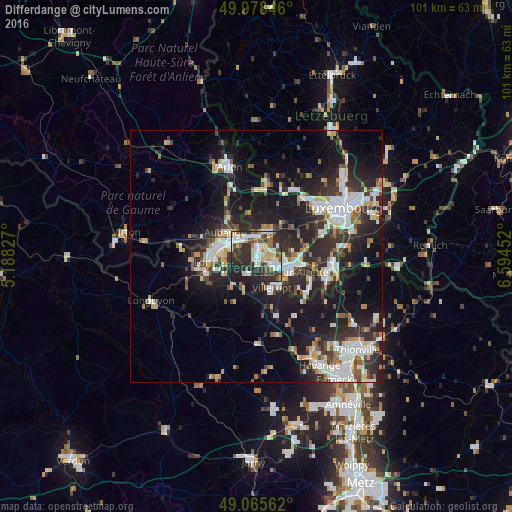
Analysis of Differdange night lights 2016
Square area 10x10 km:
 12.89%
90-99
12.61%80-89
7.14%70-79
5.46%60-69
3.5%50-59
5.32%40-49
8.54%30-39
11.06%20-29
28.15%10-19
5.32%0-9
0%Square area 50x50 km:
4.55%90-99
4.49%80-89
2.26%70-79
1.99%60-69
1.86%50-59
2.39%40-49
2.52%30-39
3.91%20-29
9.92%10-19
16.59%0-9
49.53%Clear (daylight) street map image can be seen on geolist.org.
Map coordinates:
49° 58' 42.5" North, 5° 11' 17.8" East
49° 31' 27" North, 5° 53' 29" East
49° 3' 56.2" North, 6° 35' 40.3" East
Some cities around Differdange sort by population:
• Esch-sur-Alzette
7.2 km =4.5 mi,  116°
116°
• Aubange, BE
7.8 km =4.8 mi,  307°
307°
• Villerupt, FR
7 km =4.3 mi,  155°
155°
• Mont-Saint-Martin, FR
8.1 km =5 mi,  285°
285°
• Schifflange
9 km =5.6 mi,  102°
102°
• Pétange
3.9 km =2.4 mi,  348°
348°
• Audun-le-Tiche, FR
7.4 km =4.6 mi,  141°
141°
• Belvaux
2.8 km =1.7 mi, 123°
2960651 (p: 5,296)
Sources (retrieved 2019-11-25):
» Earth at Night: Flat Maps 2012, 2016