Audun-le-Tiche night lights from space
Night Light of Audun-le-Tiche (Grand Est) from space (France) Src. Average luminocity for 10x10km area is 42.4566% and for 50x50km: 26.2146%.
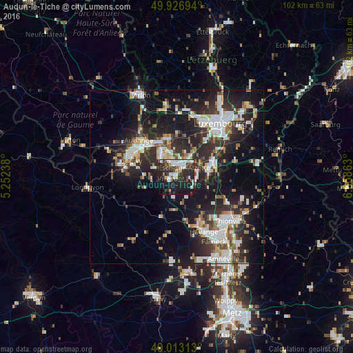
Analysis of Audun-le-Tiche night lights 2016
Square area 10x10 km:
 9.24%
9.24%90-99
11.9%80-89
1.68%70-79
1.4%60-69
2.38%50-59
2.8%40-49
7.56%30-39
6.02%20-29
26.33%10-19
28.01%0-9
2.66%Square area 50x50 km:
5.13%90-99
5.43%80-89
2.48%70-79
2.12%60-69
2.21%50-59
2.79%40-49
3.05%30-39
4.37%20-29
10.6%10-19
18.74%0-9
43.07%Clear (daylight) street map image can be seen on geolist.org.
Map coordinates:
49° 55' 37" North, 5° 15' 8.6" East
49° 28' 19.8" North, 5° 57' 19.8" East
49° 0' 47.3" North, 6° 39' 31.1" East
Some cities around Audun-le-Tiche sort by population:
• Esch-sur-Alzette, LU
3.2 km =2 mi,  34°
34°
• Dudelange, LU
9.6 km =6 mi,  84°
84°
• Villerupt
1.8 km =1.1 mi,  251°
251°
• Schifflange, LU
5.6 km =3.5 mi,  47°
47°
• Bettembourg, LU
11.8 km =7.3 mi,  64°
64°
• Pétange, LU
11 km =6.8 mi,  330°
330°
• Belvaux, LU
4.8 km =3 mi, 331°
• Differdange, LU
7.4 km =4.6 mi,  321°
321°
3036226 (p: 5,935)
Sources (retrieved 2019-11-25):
» Earth at Night: Flat Maps 2012, 2016