Kuliyapitiya night lights from space
Night Light of Kuliyapitiya (North Western) from space (Sri Lanka) Src. Average luminocity for 10x10km area is 7.4654% and for 50x50km: 5.1082%.
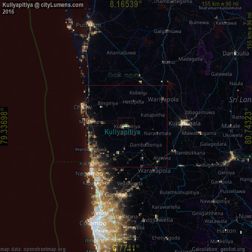
Analysis of Kuliyapitiya night lights 2016
Square area 10x10 km:
 0%
0%90-99
0.87%80-89
1.73%70-79
0.87%60-69
1.08%50-59
1.52%40-49
1.52%30-39
1.52%20-29
2.16%10-19
0.87%0-9
87.88%Square area 50x50 km:
0%90-99
0.26%80-89
0.5%70-79
0.57%60-69
0.83%50-59
1.02%40-49
1.37%30-39
2.03%20-29
2.1%10-19
3.88%0-9
87.46%Clear (daylight) street map image can be seen on geolist.org.
Map coordinates:
8° 9' 55.4" North, 79° 20' 13.1" East
7° 28' 7.7" North, 80° 2' 24.4" East
6° 46' 16" North, 80° 44' 35.6" East
Some cities around Kuliyapitiya sort by population:
• Negombo
36.7 km =22.8 mi,  217°
217°
• Katunayaka
37.2 km =23.1 mi,  206°
206°
• Ja Ela
46.8 km =29.1 mi,  200°
200°
• Kurunegala
36.2 km =22.5 mi,  87°
87°
• Chilaw
29.5 km =18.3 mi,  293°
293°
• Kegalle
41.2 km =25.6 mi,  125°
125°
• Gampaha
42.5 km =26.4 mi,  187°
187°
• Minuwangoda
35 km =21.7 mi, 195°
1238427 (p: 6,877)
Sources (retrieved 2019-11-25):
» Earth at Night: Flat Maps 2012, 2016