Minuwangoda night lights from space
Night Light of Minuwangoda (Western) from space (Sri Lanka) Src. Average luminocity for 10x10km area is 31.9848% and for 50x50km: 21.2653%.
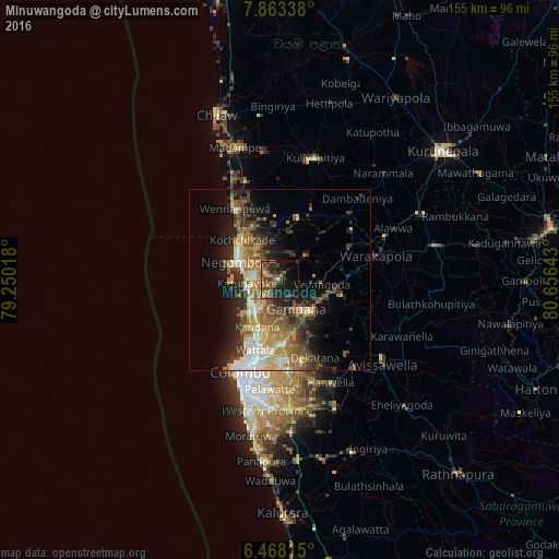
Analysis of Minuwangoda night lights 2016
Square area 10x10 km:
 0%
0%90-99
1.95%80-89
2.81%70-79
3.25%60-69
9.09%50-59
5.41%40-49
16.23%30-39
6.06%20-29
14.07%10-19
20.78%0-9
20.35%Square area 50x50 km:
2.09%90-99
3.1%80-89
2.6%70-79
3.47%60-69
4.12%50-59
3.65%40-49
4.2%30-39
3.9%20-29
5.89%10-19
9.22%0-9
57.75%Clear (daylight) street map image can be seen on geolist.org.
Map coordinates:
7° 51' 48.2" North, 79° 15' 0.6" East
7° 9' 58.7" North, 79° 57' 11.9" East
6° 28' 5.3" North, 80° 39' 23.1" East
Some cities around Minuwangoda sort by population:
• Negombo
13.8 km =8.6 mi,  289°
289°
• Katunayaka
7.2 km =4.5 mi,  273°
273°
• Hendala
21 km =13 mi,  201°
201°
• Welisara
16.4 km =10.2 mi, 200°
• Kandana
14.7 km =9.1 mi,  206°
206°
• Ja Ela
12.3 km =7.6 mi, 213°
• Wattala
20.8 km =12.9 mi, 199°
• Gampaha
9.6 km =6 mi,  153°
153°
1235000 (p: 7,772)
Sources (retrieved 2019-11-25):
» Earth at Night: Flat Maps 2012, 2016