Kegalle night lights from space
Night Light of Kegalle (Sabaragamuwa) from space (Sri Lanka) Src. Average luminocity for 10x10km area is 2.171% and for 50x50km: 0.981%.
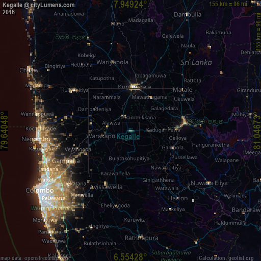
Analysis of Kegalle night lights 2016
Square area 10x10 km:
 0%
0%90-99
0%80-89
0%70-79
0.22%60-69
0.65%50-59
0.87%40-49
0.87%30-39
0%20-29
1.08%10-19
1.52%0-9
94.81%Square area 50x50 km:
0%90-99
0.04%80-89
0.16%70-79
0.08%60-69
0.07%50-59
0.11%40-49
0.13%30-39
0.5%20-29
0.57%10-19
0.64%0-9
97.69%Clear (daylight) street map image can be seen on geolist.org.
Map coordinates:
7° 56' 57.3" North, 79° 38' 25.7" East
7° 15' 8.3" North, 80° 20' 37" East
6° 33' 15.4" North, 81° 2' 48.2" East
Some cities around Kegalle sort by population:
• Kandy
32.3 km =20.1 mi,  82°
82°
• Matale
39.1 km =24.3 mi,  51°
51°
• Kurunegala
25.9 km =16.1 mi,  6°
6°
• Gampola
26.8 km =16.7 mi,  111°
111°
• Hanwella Ihala
48.3 km =30 mi,  216°
216°
• Gampaha
42.7 km =26.5 mi,  244°
244°
• Minuwangoda
44.1 km =27.4 mi,  257°
257°
• Kuliyapitiya
41.2 km =25.6 mi,  305°
305°
1240723 (p: 17,962)
Sources (retrieved 2019-11-25):
» Earth at Night: Flat Maps 2012, 2016