Saryaghash night lights from space
Night Light of Saryaghash (South Kazakhstan) from space (Kazakhstan) Src. Average luminocity for 10x10km area is 32.6803% and for 50x50km: 24.9544%.
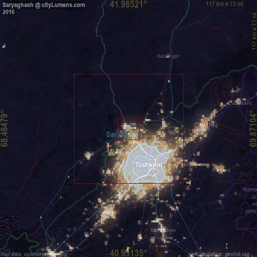

Analysis of Saryaghash night lights 2016
Square area 10x10 km:
 0.34%
0.34%90-99
1.7%80-89
3.57%70-79
3.91%60-69
7.82%50-59
10.88%40-49
7.82%30-39
9.69%20-29
12.24%10-19
21.26%0-9
20.75%Square area 50x50 km:
9.05%90-99
4.74%80-89
2.36%70-79
2.41%60-69
2.96%50-59
2.68%40-49
2.56%30-39
2.97%20-29
3.6%10-19
4.6%0-9
62.09%Clear (daylight) street map image can be seen on geolist.org.
Map coordinates:
41° 59' 6.8" North, 68° 27' 53.2" East
41° 27' 37.5" North, 69° 10' 4.5" East
40° 55' 52.9" North, 69° 52' 15.7" East
Some cities around Saryaghash sort by population:
• Tashkent, UZ
22.1 km =13.7 mi,  169°
169°
• Chirchiq, UZ
34.5 km =21.4 mi,  88°
88°
• Yangiyŭl, UZ
40 km =24.9 mi,  194°
194°
• Qibray, UZ
26 km =16.2 mi,  107°
107°
• Salor, UZ
20.3 km =12.6 mi,  118°
118°
• Bektemir, UZ
31.1 km =19.3 mi,  153°
153°
• Leninskoye
37.5 km =23.3 mi,  28°
28°
• Ŭrtaowul, UZ
30.5 km =19 mi,  183°
183°
1519673 (p: 25,139)
Sources (retrieved 2019-11-25):
» Earth at Night: Flat Maps 2012, 2016