Leninskoye night lights from space
Night Light of Leninskoye (South Kazakhstan) from space (Kazakhstan) Src. Average luminocity for 10x10km area is 0.7711% and for 50x50km: 0.2708%.
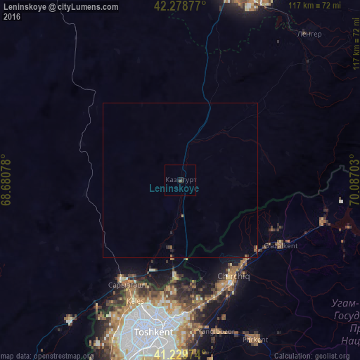
Analysis of Leninskoye night lights 2016
Square area 10x10 km:
 0%
0%90-99
0%80-89
0%70-79
0%60-69
0%50-59
0%40-49
0.49%30-39
0.49%20-29
1.46%10-19
0.16%0-9
97.4%Square area 50x50 km:
0%90-99
0%80-89
0.03%70-79
0.01%60-69
0.04%50-59
0.08%40-49
0.03%30-39
0.08%20-29
0.14%10-19
0.09%0-9
99.5%Clear (daylight) street map image can be seen on geolist.org.
Map coordinates:
42° 16' 43.6" North, 68° 40' 50.8" East
41° 45' 23" North, 69° 23' 2" East
41° 13' 47.1" North, 70° 5' 13.3" East
Some cities around Leninskoye sort by population:
• Tashkent, UZ
56.4 km =35 mi,  194°
194°
• Chirchiq, UZ
36 km =22.4 mi,  152°
152°
• Parkent, UZ
56.8 km =35.3 mi, 154°
• Qibray, UZ
41.3 km =25.7 mi,  170°
170°
• Iskandar, UZ
34.6 km =21.5 mi,  130°
130°
• Salor, UZ
42.7 km =26.5 mi,  180°
180°
• Saryaghash
37.5 km =23.3 mi,  208°
208°
• G‘azalkent, UZ
39 km =24.2 mi,  124°
124°
1521351 (p: 14,737)
Sources (retrieved 2019-11-25):
» Earth at Night: Flat Maps 2012, 2016