Leninskiy night lights from space
Night Light of Leninskiy (Pavlodar Region) from space (Kazakhstan) Src. Average luminocity for 10x10km area is 2.6032% and for 50x50km: 6.3898%.
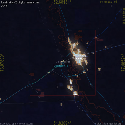
Analysis of Leninskiy night lights 2016
Square area 10x10 km:
 0%
0%90-99
0%80-89
0%70-79
0%60-69
0.4%50-59
0.66%40-49
1.85%30-39
1.85%20-29
0.53%10-19
0%0-9
94.71%Square area 50x50 km:
1.19%90-99
1.26%80-89
0.47%70-79
0.68%60-69
0.67%50-59
0.91%40-49
0.65%30-39
0.91%20-29
1.79%10-19
4.45%0-9
87.03%Clear (daylight) street map image can be seen on geolist.org.
Map coordinates:
52° 40' 54.5" North, 76° 4' 44.4" East
52° 15' 12.5" North, 76° 46' 55.6" East
51° 49' 15.4" North, 77° 29' 6.9" East
Some cities around Leninskiy sort by population:
• Pavlodar
13 km =8.1 mi,  75°
75°
• Ekibastuz
116 km =72.1 mi,  239°
239°
• Aksu
25.7 km =16 mi,  157°
157°
• Yarovoye, RU
142.7 km =88.7 mi,  58°
58°
• Irtyshsk
149.5 km =92.9 mi,  323°
323°
• Qashyr
101.3 km =62.9 mi,  333°
333°
• Mayqayyng
111 km =69 mi,  217°
217°
• Kalkaman
61.4 km =38.2 mi, 237°
1521365 (p: 8,646)
Sources (retrieved 2019-11-25):
» Earth at Night: Flat Maps 2012, 2016