Balykshi night lights from space
Night Light of Balykshi (Atyraū) from space (Kazakhstan) Src. Average luminocity for 10x10km area is 37.2741% and for 50x50km: 4.6704%.
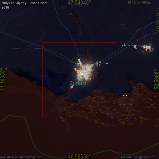
Analysis of Balykshi night lights 2016
Square area 10x10 km:
 9.09%
9.09%90-99
9.23%80-89
3.27%70-79
1.7%60-69
6.68%50-59
4.4%40-49
1.85%30-39
1.99%20-29
9.8%10-19
21.88%0-9
30.11%Square area 50x50 km:
0.73%90-99
0.98%80-89
0.57%70-79
0.46%60-69
0.7%50-59
0.51%40-49
0.42%30-39
0.7%20-29
1.29%10-19
2.99%0-9
90.65%Clear (daylight) street map image can be seen on geolist.org.
Map coordinates:
47° 32' 36.4" North, 51° 9' 48.8" East
47° 4' 0" North, 51° 52' 0" East
46° 35' 8.1" North, 52° 34' 11.3" East
Some cities around Balykshi sort by population:
• Atyrau
5.7 km =3.5 mi,  12°
12°
• Qulsary
163.7 km =101.7 mi,  94°
94°
• Maqat
127 km =78.9 mi,  59°
59°
• Inderbor
165 km =102.5 mi,  357°
357°
• Dossor
98.4 km =61.1 mi, 58°
• Qaraton
142 km =88.2 mi,  119°
119°
• Makhambet
70 km =43.5 mi,  342°
342°
• Maloye Ganyushkino
204.5 km =127.1 mi,  255°
255°
610445 (p: 19,260)
Sources (retrieved 2019-11-25):
» Earth at Night: Flat Maps 2012, 2016