Yuza night lights from space
Night Light of Yuza (Yamagata) from space (Japan) Src. Average luminocity for 10x10km area is 1.6769% and for 50x50km: 2.1979%.
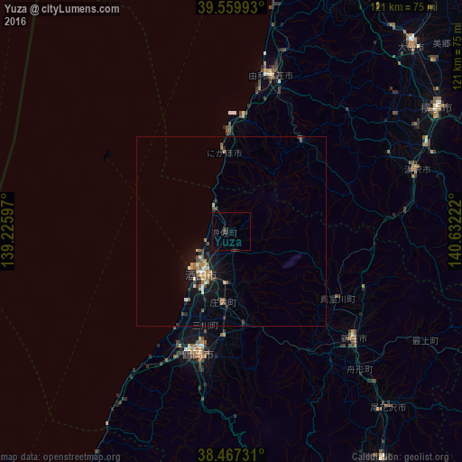
Analysis of Yuza night lights 2016
Square area 10x10 km:
 0%
0%90-99
0%80-89
0%70-79
0%60-69
0%50-59
0.16%40-49
0.49%30-39
0.65%20-29
2.6%10-19
0%0-9
96.1%Square area 50x50 km:
0.09%90-99
0.21%80-89
0.3%70-79
0.31%60-69
0.38%50-59
0.28%40-49
0.39%30-39
0.34%20-29
0.52%10-19
2.02%0-9
95.17%Clear (daylight) street map image can be seen on geolist.org.
Map coordinates:
39° 33' 35.7" North, 139° 13' 33.5" East
39° 0' 56.6" North, 139° 55' 44.7" East
38° 28' 2.3" North, 140° 37' 56" East
Some cities around Yuza sort by population:
• Sakata
12.7 km =7.9 mi,  210°
210°
• Tsuruoka
34 km =21.1 mi,  195°
195°
• Higashine
76.1 km =47.3 mi,  147°
147°
• Shinjō
43 km =26.7 mi,  131°
131°
• Yokote
63.2 km =39.3 mi,  57°
57°
• Ōmagari
67.9 km =42.2 mi,  44°
44°
• Yuzawa
52 km =32.3 mi,  71°
71°
• Obanazawa
61.5 km =38.2 mi,  138°
138°
1848016 (p: 17,082)
Sources (retrieved 2019-11-25):
» Earth at Night: Flat Maps 2012, 2016