Tomobe night lights from space
Night Light of Tomobe (Ibaraki) from space (Japan) Src. Average luminocity for 10x10km area is 23.9615% and for 50x50km: 17.1882%.

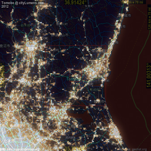
Analysis of Tomobe night lights 2016
Square area 10x10 km:
100  0%
0%
90-99 0.7%
80-89 2.1%
70-79 2.27%
60-69 5.94%
50-59 7.34%
40-49 5.24%
30-39 4.55%
20-29 7.69%
10-19 29.72%
0-9 34.44%
0%90-99
0.7%80-89
2.1%70-79
2.27%60-69
5.94%50-59
7.34%40-49
5.24%30-39
4.55%20-29
7.69%10-19
29.72%0-9
34.44%Square area 50x50 km:
100 1.01%
90-99 2.07%
80-89 1.5%
70-79 1.96%
60-69 2.64%
50-59 3.67%
40-49 3.49%
30-39 3.85%
20-29 6.01%
10-19 13.88%
0-9 59.93%
1.01%90-99
2.07%80-89
1.5%70-79
1.96%60-69
2.64%50-59
3.67%40-49
3.49%30-39
3.85%20-29
6.01%10-19
13.88%0-9
59.93%Clear (daylight) street map image can be seen on geolist.org.
Map coordinates:
36° 54' 51.3" North, 139° 35' 48.8" East
36° 21' 0" North, 140° 18' 0" East
35° 46' 53.9" North, 141° 0' 11.3" East
Some cities around Tomobe sort by population:
• Mito
13.4 km =8.3 mi,  90°
90°
• Katsuta
21.2 km =13.2 mi,  79°
79°
• Ishioka
18.8 km =11.7 mi,  189°
189°
• Okunoya
12.8 km =8 mi,  125°
125°
• Kasama
4.8 km =3 mi,  321°
321°
• Iwase
17.9 km =11.1 mi,  270°
270°
• Motegi
21.3 km =13.2 mi,  330°
330°
• Makabe
20.2 km =12.6 mi,  242°
242°
2110743 (p: 37,146)
Sources (retrieved 2019-11-25):
» Earth at Night: Flat Maps 2012, 2016