Makabe night lights from space
Night Light of Makabe (Ibaraki) from space (Japan) Src. Average luminocity for 10x10km area is 5.2238% and for 50x50km: 23.6065%.
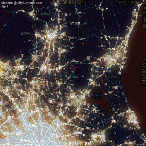
Analysis of Makabe night lights 2016
Square area 10x10 km:
100  0%
0%
90-99 1.4%
80-89 0%
70-79 0%
60-69 0%
50-59 0%
40-49 1.92%
30-39 2.97%
20-29 1.4%
10-19 1.05%
0-9 91.26%
0%90-99
1.4%80-89
0%70-79
0%60-69
0%50-59
0%40-49
1.92%30-39
2.97%20-29
1.4%10-19
1.05%0-9
91.26%Square area 50x50 km:
100 1.26%
90-99 3.02%
80-89 1.83%
70-79 2.58%
60-69 3.46%
50-59 4.66%
40-49 5.29%
30-39 6.23%
20-29 10.74%
10-19 22.84%
0-9 38.07%
1.26%90-99
3.02%80-89
1.83%70-79
2.58%60-69
3.46%50-59
4.66%40-49
5.29%30-39
6.23%20-29
10.74%10-19
22.84%0-9
38.07%Clear (daylight) street map image can be seen on geolist.org.
Map coordinates:
36° 49' 53.5" North, 139° 23' 48.8" East
36° 16' 0" North, 140° 6' 0" East
35° 41' 51.8" North, 140° 48' 11.3" East
Some cities around Makabe sort by population:
• Tsukuba
7.4 km =4.6 mi,  180°
180°
• Mooka
20 km =12.4 mi,  338°
338°
• Shimodate
11.1 km =6.9 mi,  289°
289°
• Ishioka
17.6 km =10.9 mi,  121°
121°
• Yūki
19.8 km =12.3 mi,  280°
280°
• Tomobe
20.2 km =12.6 mi,  62°
62°
• Kasama
19.8 km =12.3 mi,  49°
49°
• Iwase
9.3 km =5.8 mi,  0°
0°
2112019 (p: 19,293)
Sources (retrieved 2019-11-25):
» Earth at Night: Flat Maps 2012, 2016