Kasama night lights from space
Night Light of Kasama (Ibaraki) from space (Japan) Src. Average luminocity for 10x10km area is 14.0577% and for 50x50km: 15.7084%.
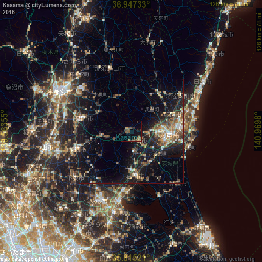
Analysis of Kasama night lights 2016
Square area 10x10 km:
 0%
0%90-99
0%80-89
0.7%70-79
1.22%60-69
3.32%50-59
5.59%40-49
3.85%30-39
4.2%20-29
2.1%10-19
7.69%0-9
71.33%Square area 50x50 km:
0.97%90-99
2.07%80-89
1.31%70-79
1.67%60-69
2.36%50-59
2.97%40-49
3.15%30-39
3.12%20-29
5.1%10-19
15.08%0-9
62.2%Clear (daylight) street map image can be seen on geolist.org.
Map coordinates:
36° 56' 50.4" North, 139° 33' 48.8" East
36° 22' 60" North, 140° 16' 0" East
35° 48' 54.8" North, 140° 58' 11.3" East
Some cities around Kasama sort by population:
• Mito
16.8 km =10.4 mi,  102°
102°
• Ishioka
22.2 km =13.8 mi,  180°
180°
• Tomobe
4.8 km =3 mi,  141°
141°
• Okunoya
17.4 km =10.8 mi,  129°
129°
• Mashiko
17.6 km =10.9 mi,  301°
301°
• Iwase
15.4 km =9.6 mi,  256°
256°
• Motegi
16.6 km =10.3 mi,  333°
333°
• Makabe
19.8 km =12.3 mi,  229°
229°
2112343 (p: 29,477)
Sources (retrieved 2019-11-25):
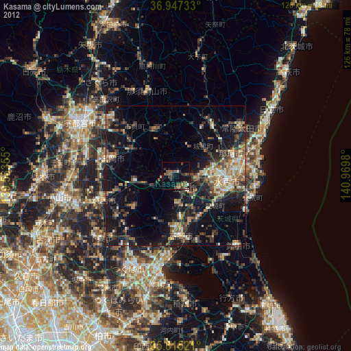
» Earth at Night: Flat Maps 2012, 2016