Ishikawa night lights from space
Night Light of Ishikawa (Fukushima) from space (Japan) Src. Average luminocity for 10x10km area is 1.7976% and for 50x50km: 4.2164%.
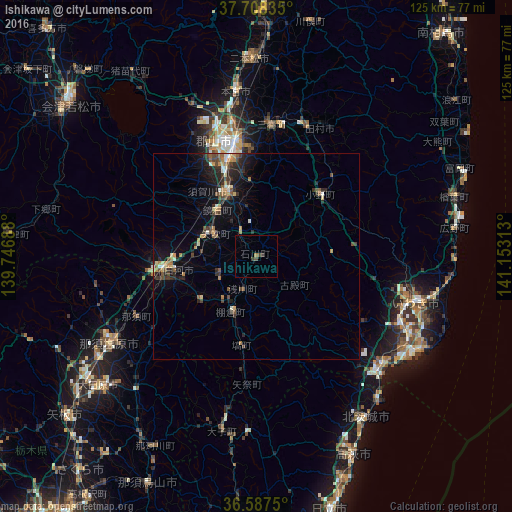
Analysis of Ishikawa night lights 2016
Square area 10x10 km:
 0%
0%90-99
0%80-89
0%70-79
0%60-69
0.68%50-59
0%40-49
1.19%30-39
1.53%20-29
0%10-19
0%0-9
96.6%Square area 50x50 km:
0.16%90-99
0.47%80-89
0.34%70-79
0.64%60-69
0.57%50-59
0.69%40-49
0.83%30-39
0.88%20-29
1.65%10-19
3.01%0-9
90.76%Clear (daylight) street map image can be seen on geolist.org.
Map coordinates:
37° 42' 30.1" North, 139° 44' 48.8" East
37° 9' 0" North, 140° 27' 0" East
36° 35' 15" North, 141° 9' 11.3" East
Some cities around Ishikawa sort by population:
• Iwaki
40 km =24.9 mi,  106°
106°
• Kōriyama
28.4 km =17.6 mi,  348°
348°
• Sukagawa
16 km =9.9 mi,  338°
338°
• Kuroiso
40.9 km =25.4 mi,  240°
240°
• Funehikimachi-funehiki
34.9 km =21.7 mi,  18°
18°
• Motomiya
40.7 km =25.3 mi, 353°
• Daigo
43.5 km =27 mi,  191°
191°
• Miharu
31.6 km =19.6 mi,  5°
5°
2112583 (p: 18,817)
Sources (retrieved 2019-11-25):
» Earth at Night: Flat Maps 2012, 2016