Miharu night lights from space
Night Light of Miharu (Fukushima) from space (Japan) Src. Average luminocity for 10x10km area is 11.9075% and for 50x50km: 7.7126%.
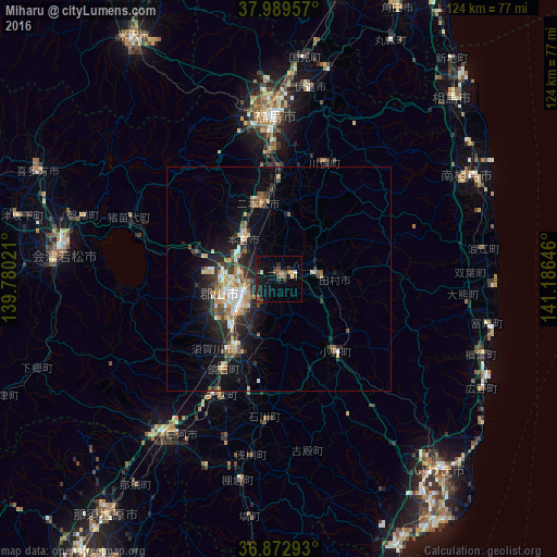
Analysis of Miharu night lights 2016
Square area 10x10 km:
 0%
0%90-99
1.3%80-89
0.65%70-79
0.81%60-69
0.81%50-59
3.08%40-49
3.25%30-39
0.32%20-29
6.01%10-19
11.53%0-9
72.24%Square area 50x50 km:
0.6%90-99
1.42%80-89
0.76%70-79
1%60-69
0.95%50-59
1%40-49
1.24%30-39
1.38%20-29
2.71%10-19
5.11%0-9
83.84%Clear (daylight) street map image can be seen on geolist.org.
Map coordinates:
37° 59' 22.5" North, 139° 46' 48.8" East
37° 25' 60" North, 140° 28' 60" East
36° 52' 22.5" North, 141° 11' 11.3" East
Some cities around Miharu sort by population:
• Kōriyama
9.6 km =6 mi,  247°
247°
• Fukushima
35.2 km =21.9 mi,  357°
357°
• Sukagawa
18.9 km =11.7 mi,  207°
207°
• Nihommatsu
17.3 km =10.7 mi,  345°
345°
• Funehikimachi-funehiki
8.4 km =5.2 mi,  79°
79°
• Motomiya
11.6 km =7.2 mi,  320°
320°
• Ishikawa
31.6 km =19.6 mi,  185°
185°
• Inawashiro
35.6 km =22.1 mi,  294°
294°
2111943 (p: 19,708)
Sources (retrieved 2019-11-25):
» Earth at Night: Flat Maps 2012, 2016