Fujioka night lights from space
Night Light of Fujioka (Tochigi) from space (Japan) Src. Average luminocity for 10x10km area is 25.1416% and for 50x50km: 41.2183%.
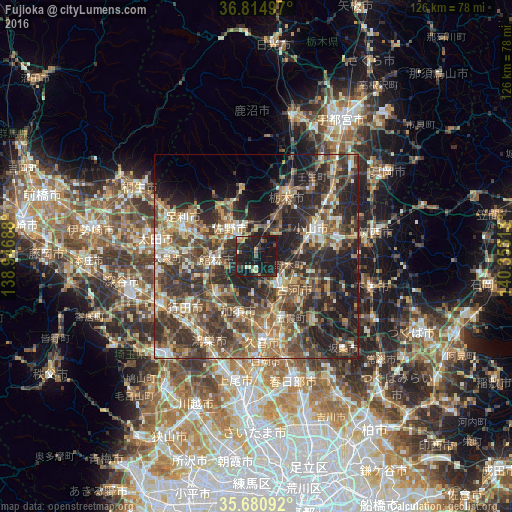
Analysis of Fujioka night lights 2016
Square area 10x10 km:
100  0.52%
0.52%
90-99 3.85%
80-89 2.27%
70-79 3.15%
60-69 0.7%
50-59 2.8%
40-49 1.4%
30-39 5.42%
20-29 15.03%
10-19 64.34%
0-9 0.52%
0.52%90-99
3.85%80-89
2.27%70-79
3.15%60-69
0.7%50-59
2.8%40-49
1.4%30-39
5.42%20-29
15.03%10-19
64.34%0-9
0.52%Square area 50x50 km:
100 2.52%
90-99 6.34%
80-89 4.44%
70-79 5.93%
60-69 7.97%
50-59 8.24%
40-49 10.5%
30-39 11.61%
20-29 15.26%
10-19 15.82%
0-9 11.37%
2.52%90-99
6.34%80-89
4.44%70-79
5.93%60-69
7.97%50-59
8.24%40-49
10.5%30-39
11.61%20-29
15.26%10-19
15.82%0-9
11.37%Clear (daylight) street map image can be seen on geolist.org.
Map coordinates:
36° 48' 53.9" North, 138° 56' 48.8" East
36° 15' 0" North, 139° 39' 0" East
35° 40' 51.3" North, 140° 21' 11.3" East
Some cities around Fujioka sort by population:
• Oyama
14.5 km =9 mi,  67°
67°
• Sano
9.5 km =5.9 mi,  321°
321°
• Tatebayashi
10.5 km =6.5 mi,  270°
270°
• Kazo
15.5 km =9.6 mi,  196°
196°
• Hanyū
14 km =8.7 mi,  228°
228°
• Koga
9.5 km =5.9 mi,  141°
141°
• Tanuma
14.3 km =8.9 mi,  335°
335°
• Kurihashi
13.7 km =8.5 mi,  160°
160°
1864098 (p: 18,335)
Sources (retrieved 2019-11-25):
» Earth at Night: Flat Maps 2012, 2016