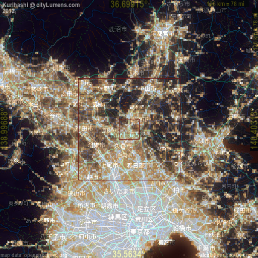
Kurihashi night lights from space
Night Light of Kurihashi (Saitama) from space (Japan) Src. Average luminocity for 10x10km area is 56.674% and for 50x50km: 51.5714%.

Analysis of Kurihashi night lights 2016
Square area 10x10 km:
100  2.38%
2.38%
90-99 6.23%
80-89 5.86%
70-79 9.34%
60-69 17.95%
50-59 19.96%
40-49 17.22%
30-39 13.92%
20-29 6.96%
10-19 0.18%
0-9 0%
2.38%90-99
6.23%80-89
5.86%70-79
9.34%60-69
17.95%50-59
19.96%40-49
17.22%30-39
13.92%20-29
6.96%10-19
0.18%0-9
0%Square area 50x50 km:
100 4.95%
90-99 8.75%
80-89 5.89%
70-79 7.59%
60-69 11.51%
50-59 10.53%
40-49 11.28%
30-39 11.89%
20-29 14.14%
10-19 13.41%
0-9 0.08%
4.95%90-99
8.75%80-89
5.89%70-79
7.59%60-69
11.51%50-59
10.53%40-49
11.28%30-39
11.89%20-29
14.14%10-19
13.41%0-9
0.08%Clear (daylight) street map image can be seen on geolist.org.
Map coordinates:
36° 41' 56.9" North, 138° 59' 48.8" East
36° 7' 60" North, 139° 42' 0" East
35° 33' 48.2" North, 140° 24' 11.3" East
Some cities around Kurihashi sort by population:
• Kukichūō
7.7 km =4.8 mi,  197°
197°
• Kazo
9.2 km =5.7 mi,  258°
258°
• Koga
5.8 km =3.6 mi,  15°
15°
• Satte
7.2 km =4.5 mi,  160°
160°
• Sugito
11.6 km =7.2 mi,  168°
168°
• Sakai
9.7 km =6 mi,  112°
112°
• Shōbu
11.6 km =7.2 mi,  230°
230°
• Kisai
11.1 km =6.9 mi,  250°
250°
1858283 (p: 27,813)
Sources (retrieved 2019-11-25):
» Earth at Night: Flat Maps 2012, 2016