Enzan night lights from space
Night Light of Enzan (Yamanashi) from space (Japan) Src. Average luminocity for 10x10km area is 11.229% and for 50x50km: 9.262%.
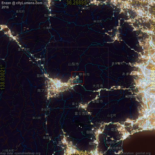

Analysis of Enzan night lights 2016
Square area 10x10 km:
 0%
0%90-99
0%80-89
0.7%70-79
0.7%60-69
0.7%50-59
2.8%40-49
4.37%30-39
5.59%20-29
5.59%10-19
8.74%0-9
70.8%Square area 50x50 km:
0.56%90-99
1.44%80-89
1.11%70-79
1.18%60-69
1.2%50-59
2.1%40-49
2.46%30-39
1.71%20-29
2.65%10-19
4.22%0-9
81.38%Clear (daylight) street map image can be seen on geolist.org.
Map coordinates:
36° 16' 8.2" North, 138° 1' 48.8" East
35° 42' 0" North, 138° 43' 60" East
35° 7' 37.1" North, 139° 26' 11.3" East
Some cities around Enzan sort by population:
• Kōfu
15.5 km =9.6 mi,  256°
256°
• Fujiyoshida
29.4 km =18.3 mi,  168°
168°
• Hokuto
33.9 km =21.1 mi,  296°
296°
• Ryūō
21.8 km =13.5 mi, 255°
• Nirasaki
25.6 km =15.9 mi,  270°
270°
• Ōtsuki
23.6 km =14.7 mi,  112°
112°
• Isawa
10.6 km =6.6 mi,  238°
238°
• Fujikawaguchiko
23.8 km =14.8 mi,  189°
189°
1864180 (p: 25,142)
Sources (retrieved 2019-11-25):
» Earth at Night: Flat Maps 2012, 2016