Aydūn night lights from space
Night Light of Aydūn (Irbid) from space (Jordan) Src. Average luminocity for 10x10km area is 76.5733% and for 50x50km: 42.3273%.
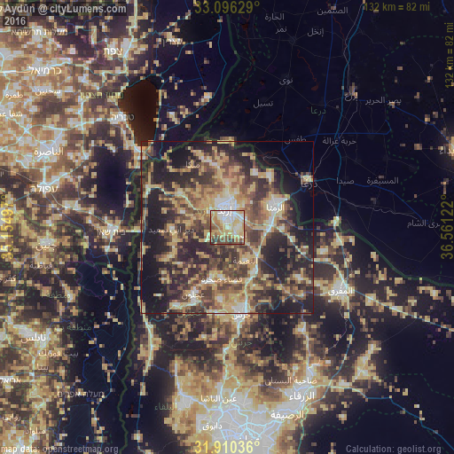
Analysis of Aydūn night lights 2016
Square area 10x10 km:
100  13.55%
90-99 15.2%
80-89 24.73%
70-79 15.02%
60-69 9.89%
50-59 9.89%
40-49 6.23%
30-39 4.58%
20-29 0.92%
10-19 0%
0-9 0%
13.55%90-99
15.2%80-89
24.73%70-79
15.02%60-69
9.89%50-59
9.89%40-49
6.23%30-39
4.58%20-29
0.92%10-19
0%0-9
0%Square area 50x50 km:
100 2.79%
90-99 3.91%
80-89 9.51%
70-79 8.03%
60-69 5.85%
50-59 6.88%
40-49 10.84%
30-39 9.24%
20-29 14.05%
10-19 17.8%
0-9 11.1%
2.79%90-99
3.91%80-89
9.51%70-79
8.03%60-69
5.85%50-59
6.88%40-49
10.84%30-39
9.24%20-29
14.05%10-19
17.8%0-9
11.1%Clear (daylight) street map image can be seen on geolist.org.
Map coordinates:
33° 5' 46.6" North, 35° 9' 17.9" East
32° 30' 19" North, 35° 51' 29.1" East
31° 54' 37.3" North, 36° 33' 40.4" East
Some cities around Aydūn sort by population:
• Irbid
5.6 km =3.5 mi,  352°
352°
• Bayt Yāfā
7 km =4.3 mi,  285°
285°
• Ḩakamā
10.1 km =6.3 mi,  13°
13°
• Sāl
8.7 km =5.4 mi,  35°
35°
• Dayr Yūsuf
6.1 km =3.8 mi,  250°
250°
• Kitim
8.3 km =5.2 mi,  154°
154°
• Tibnah
12.4 km =7.7 mi, 254°
• Qumaym
13.7 km =8.5 mi,  302°
302°
250152 (p: 18,376)
Sources (retrieved 2019-11-25):
» Earth at Night: Flat Maps 2012, 2016